GLOBE News


Comfortable Using the Open Altimetry Online Tool to Compare Tree Height Data? Check out Recent Blog with Tutorials
GLOBE Community: Read the recent Community Blog written by Brian Campbell, NASA Senior Earth Science Education Specialist, “Are You Comfortable Using the Open Altimetry Online Tool to Compare your Tree Height Data to ICESat-2 Satellite Data?”
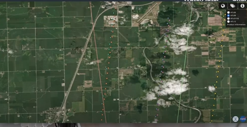
“Did you know that you can compare your GLOBE tree height data to that of the ICESat-2 satellite? You can compare any GLOBE tree height data to ICESat-2 tree height data using the Open Altimetry online tool at http://openaltimetry.org. This online tool is set up to be very user-friendly, but does require a bit of exploration to use it properly,” Campbell said in the blog.
In the blog, Campbell shares two tutorials that explain how the Open Altimetry tool works, and how GLOBE community members participating in the Trees Around the GLOBE Student Research Campaign can get more comfortable looking at data and comparing it to the ICESat-2 data for tree height.
“By comparing this data, students can see just how close the satellite tracks over their locations and if certain GLOBE-measured trees have been measured by ICESat-2.”
To read the blog, click here.
To learn more about the Trees Around the GLOBE Student Research Campaign, click here.
type: globe-newsNews origin: GLOBE Implementation Office