GLOBE News


Article Highlights GLOBE Observer App and Ability of Citizen Scientists to Help Track Global Environmental Change
A recent article, “Photonics Tracks Global Environmental Change,” written by Patricia Daukantas and published in Optics and Photonics (November 2019), highlights the efforts of “optical scientists” and “citizen scientists” to take globe-spanning measurements of ice, water, gases, and the biosphere to help track global environmental change.
“Nearly every day brings news about climate change and its impacts, from wildfires in Greenland to melting ice on Antarctica to Europeans sweating through record-high summer temperatures,” Daukantas said in the article. “These stories, plus urgent warnings about rising sea levels and record amounts of greenhouse gases, can foster strong impulses to ‘do something.’”
“One of the first jobs, though, is to know the problem—and fortunately, today’s photonics researchers have risen to the call to quantify global climate and environmental change. From wind to ice, from treetops to coral reefs, today’s most sophisticated optical instruments are examining the condition of humanity’s home planet.”
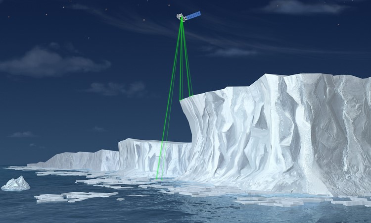
After describing the three broad categories of photonic sensing – laser ranging (which quantifies how solids increase or decrease in elevation); hyperspectral imaging (which reveals patterns of healthy and diseased life forms in their habitats); and laser spectroscopy (which fills in the “crucial gaps” in knowledge of the distribution of problematic atmospheric gases) – the author discusses a variety of research projects that use optics and photonics to keep track of environmental change, including NASA’s ICESat-2 (Ice, Cloud, and Land Elevation Satellite 2).
“Like its predecessor, ICESat-2 was designed to measure ice sheet elevation as well as sea ice volume. Much of the time, however, the spacecraft is passing over regions that lack ice. So the NASA team has devised ways to measure the mass of forest vegetation by using ICESat-2 measurements of treetop heights and the altitude of the forest floor,” Daukantas said in the article. “NASA even developed a “citizen science” tool for the GLOBE Observer smartphone app to capture local tree heights for comparison with ICESat-2 measurements.”
In May of 2019, NASA released the first set of ICESat-2 data products to the National Snow and Ice Data Center in Denver, Colorado, USA, which serves as the archive for this type of information. By mid-summer, more than 800 users had downloaded nearly half-a-million data sets, according to Tom Neumann, the NASA project scientist for ICESat-2.
After discussing these, and other application of photonics, the author concludes the article with a glimpse into historical inspiration. “Nearly 60 years ago, the leader of one nation, U.S. President John F. Kennedy, committed his country to a technological goal—landing humans on the moon—that would ‘serve to organize and measure the best of our energies and skills, because that challenge is one that we are willing to accept, one we are unwilling to postpone, and one which we intend to win.’ As world citizens, many optical scientists are diligently focusing their efforts on what will likely be the defining challenge of the decades to come.
To read the entire article, click here.
type: globe-newsNews origin: GLOBE Implementation Office