Stars and STEM Stories


Delaware Water Gap National Recreation Area Hosts GLOBE Field Campaign
Dr. Eric Brown de Colstoun, Dr. Jessica Robin and Anita Davis of Science Systems and Applications Inc. at NASA Goddard Space Flight Center, Sunny Minelli of the Northeastern Educational Intermediate Unit, and Leslie Morlock of the National Park Service organized the educational satellite validation field campaign entitled "Bridging the GAPS from Space: How to validate NASA Satellite Data in the Field" at the Pocono Environmental Education Center (PEEC). Jointly sponsored by the Landsat Program Science Office (LPSO), the Landsat Education and Public Outreach program, the National Park Service (NPS), the GLOBE Program and the Northeastern and Colonial Intermediate Units from the State of Pennsylvania, the field campaign attracted a large number and wide range of participants: science, math, and geography teachers and their middle and high school students from eleven local school districts, scientists from LPSO, staff from two national parks, the NPS Inventory and Program and NOAA. Among the over 130 attendees were the Park Superintendent and Chief of Natural Resources Division of DEWA, the Outreach Coordinator for the Environmental Institute at Lackawanna College, undergraduate students from the University of Maryland, four television stations and multiple members of the media who interviewed organizers, trainers and participants. GLOBE Master Trainers Dr. Jessica Robin, from NASA Goddard, together with Frank Niepold and John McLaughlin, representing NOAA, assisted with the training and field campaign.In Dingmans Ferry, Pennsylvania, on the grounds of the Delaware Water Gap National Recreation Area (DEWA), students, teachers, scientists and park personnel gathered recently to evaluate land-cover and satellite images of the area for the purpose of verifying the accuracy of NASA's satellite maps. Accurate analysis of land-cover provides clues to the environmental effects of urban development in the area and this day-long field campaign focused on impacts to National Parks in the Upper Delaware Basin.
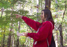
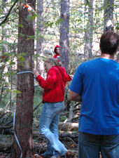
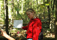
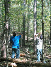
The objective of the campaign was to train teachers and students how to validate tree cover and impervious cover Landsat data sets for the Upper Delaware River Basin, which are being developed through Dr. Eric Brown de Colstoun's NASA-funded New Investigator Program project. The project aims to use Landsat to measure land cover change and urban growth in the Upper Delaware Basin over the last 20 years and to study the effect of these changes on local National Parks. Limited biometric data to support ICESAT satellite land data sets were also collected at selected sites.
Participants received a brief presentation on the research component of the project and a short training in the GLOBE GPS and Land Cover/Biology field protocols. Then, in groups of four to eight students and teachers, they went to their assigned sites in DEWA Park to make field measurements. Participants also measured two principal sites at PEEC to assess the variability between each group's measurements. One student commented, "We helped NASA to survey the area and I had fun."
This research/educational partnership between the Principal Investigator, the NPS, the PA Intermediate Units and area students and educators is one that clearly benefits the development and validation of the research. It also provides a compelling story line for a wide variety of educational activities combining NASA data and data gathered through GLOBE protocols, all within the spectacular setting of our National Parks.
See the Newpaper article.
20 November 2006