News - Gambia


SMAP Captures Views of Global Soil Moisture
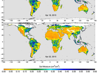
Data from the radiometer instrument on NASA's Soil Moisture Active Passive (SMAP) observatory have led to the creation of new maps of global soil moisture. The new images (each a composite of three days of SMAP radiometer data, collected in April) show the volumetric water content in the top 2 inches (5 centimeters) of soil. These uncalibrated soil moisture images will be evaluated during the calibration and validation phase of SMAP's science mission, which begins on 10 May.
SMAP, which was launched 31 January 2015, is on a 3-year mission to map global soil moisture and detect whether soils are frozen or thawed. The SMAP mission will help scientists understand the links among Earth's water, energy and carbon cycles; help reduce uncertainties in predicting weather and climate; and enhance our ability to monitor and predict natural hazards such as floods and droughts.
Scientists will combine measurements from SMAP's radiometer (which can detect differences in microwave emissions caused by water in soil) and radar sensors (which can also produce soil moisture measurements). By combining these separate measurements through advanced data processing, SMAP will provide the user community with a combined soil moisture measurement that has high accuracy and a resolution of 5.6 miles (9 kilometers).
The GLOBE Program is partnering with the SMAP mission, with the help of GLOBE students who are collecting measurements that will contribute to the SMAP calibration and validation program.
type: globe-newsNews origin: GLOBE Implementation Office