By Dr. Lin Chambers, NASA Scientist for GLOBE Student Research Campaign on Climate.
READ THIS BLOG IN SPANISH. translation by Camelia Deller
While scientists often carefully plan field campaigns in areas of the world that they are interested in, sometimes opportunities come along to make measurements where someone else is already going. For example, some cargo ships and passenger airplanes carry instruments to measure things about the atmosphere or ocean, wherever their route happens to take them. Recently, such an opportunity landed in my lap. As weather, time and the condition of the boat permit, the crew of a 64-foot sailboat called Ocean Watch has been making and reporting cloud observations for the Students’ Cloud Observations On-Line (S’COOL) Project which I direct, a small sister project to GLOBE, as the boat sails “Around the Americas” (ATA).
A joint venture between the Pacific Science Center and Sailors for the Sea, ATA, involves the Ocean Watch, making a circumnavigation of the entire North and South American continents. The boat left Seattle, Washington, in the northwestern United States on 31 May 2009 and will take about 13 months to complete the journey. It sailed through the famed Northwest Passage over the summer, then down the East Coast. Currently it is along the north coast of Brazil, heading for the tip of South America, Cape Horn. The route, so far and planned, including ports of call in several GLOBE countries (shown here).
While the main goal of the voyage is to raise awareness of the oceans, the boat is carrying a number of instruments to make measurements as they can along the way. From the ATA webpage: “Ten scientists from six institutions (University of Washington’s Applied Physics Laboratory, the Joint Institute for the Study of the Atmosphere and Ocean, RMR Co., MIT Sea Grant, NASA, and Western Washington University) have placed a diverse suite of instruments on board Ocean Watch to collect datasets of opportunity throughout the voyage. Projects span topics ranging from polar science and weather to jellyfish populations and the reflection solar energy.”
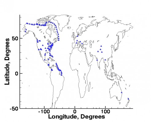
S’COOL is tied to a NASA satellite instrument called CERES (Clouds and the Earth’s Radiant Energy System). Observation times are therefore timed to the overpass of the Aqua and Terra satellites, which carry CERES instruments. The trick for the Ocean Watch crew is to time the cloud observations with the overpass of the satellites, as both sailboat and satellite are moving. Figure 1 shows a map of observation locations from the recently-launched S’COOL Rover effort, which allows people to obtain satellite overpass times for any location in the world, and through which Ocean Watch is reporting. The track of the sailboat through the Northwest Passage is clearly marked, then picks up again as they approach South America after a number of problems with weather, repairs, and crew changes. Ocean Watch provides reports from locations where neither S’COOL nor GLOBE students would normally be reporting. (Other locations around the world contributing Rover observations are also shown on this map.)

Question to ponder: Why are the points on the map farther apart through the Northwest Passage, and closer together along the South American coast?
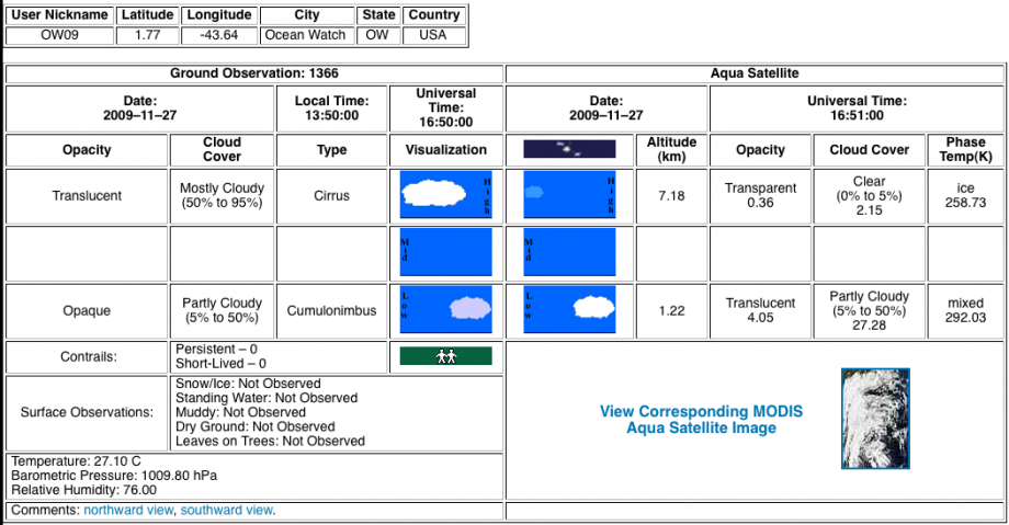
The observation reports from the Ocean Watch are accessible through the Internet. When they have successfully timed the observation with a satellite overpass, satellite data corresponding to that time and place are also summarized on that site for comparison (see example, Figure 2). For the leg picking up in the southern hemisphere, we have also worked out a way to link to digital photos being taken by the crew at observation time. This brings an extra dimension to the comparison. Our plan is to conduct a focused analysis of the entire Ocean Watch dataset, and how it compares to the satellite-retrieved information, at the conclusion of the voyage, but you can explore it now.

PLEASE NOTE:
GLOBE participants near the coast may wish to keep an eye out for upcoming ports of call, and visit the boat and its crew for more information. Be sure to check for updates to the schedule, as circumstances and weather do alter the boat’s course.
