
27 November 2007
The number of schools that have entered data in association with the surface temperature field campaign is slowly increasing. I put the list of schools that have entered data thus far at the end of this blog.
A cold front swept across the Great Lakes (figure) this afternoon. At my house in Temperance, Michigan, the temperature dropped from about 44° F (7° C) to near the freezing mark in a few hours.
Lake effect snow showers set up downwind from Lake Superior and Michigan today after the cold front went through (see the figure below; and recall from the last blog that snowfall on the downwind side of large lakes like the Great Lakes is increased because the air moistens through evaporation as it passes over the lake. This is called “lake-effect” snow).
The clouds form cloud “streets”. The clouds form parallel to the direction that the wind is blowing. From this satellite image we can tell that the winds were blowing from the north northwest near Lake Superior while the winds were more northwesterly over the main part of Michigan.
You will notice that the lakes affect air temperatures as well as clouds and snow. In Wisconsin, the air temperature when this image was taken was approximately 10° F (-12° C). On the east side of Lake Michigan in Michigan, the air temperature was 27° F (-3° C). The warm lake water of Lake Michigan warmed the air. This helps moderate the weather on the downwind sides of the lakes. In fact, there are many orchards on the western side of Michigan. The trees do not like extreme temperatures. Lake Michigan protects the area from very cold temperatures in the winter and very hot temperatures in the summer. Apples, cherries, grapes, pears and peaches are some of the fruits grown around the Great Lakes. When I was younger, I picked fruit and trimmed trees in the orchards as a summer job.
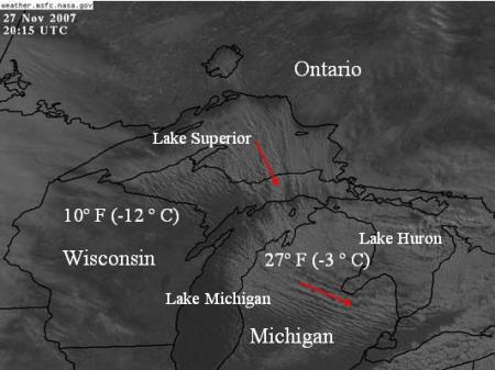
Satellite image showing cloud streets and snow around the Great Lakes, with temperatures and winds. It is difficult to tell the difference between clouds and snow in the satellite image. Both appear white. There is not much snow on the ground in this image so there should not be too much confusion. But, in Ontario, Canada, north of Lake Superior, there is snow on the ground.
Schools participating in the surface temperature field campaign thus far:
| Roswell Kent Middle School, Akron, Ohio, USA — 4 observations Lorain Community College Early College High School, Elyria, Ohio, USA Kilingi-Nomme Gymnasium, Parnumaa, Estonia — 6 observations White Cloud Public, White Cloud, Michigan, USA — 2 observations Blue Valley High School, Stilwell, Kansas, USA Roxboro Middle School, Cleveland Heights, Ohio, USA Bowling Green State University, Bowling Green, Ohio, USA Ida Elementary School, Ida, Michigan, USA — 6 observations Gimnazium in Toszek, Toszek, Poland — 14 observations Waynesboro Senior High School, Waynesboro, Pennsylvania, USA |
Dr. C