
When I was in school, I never seemed to have the right coat on. If I walked to school at 7:30 a.m. (0730) in my heavy coat, I would often be too hot on the way home at 3:30 p.m. (1530) On the other hand, it would be too cold in the morning to wear a lighter coat.
Now, as a trained meteorologist, I know the reasons why. Do you know what time of day it is the coldest? Or when it is the warmest?
Fortunately, it’s fairly easy to find some data to answer this question. On the GLOBE web site, you can find GLOBE ONE under “projects” and find data for 10 automatic weather stations from Black Hawk County, Iowa. Figure 1 shows how the temperature varied during five fair-weather days in April 2002, at Station 4.
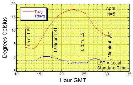
Figure 1. Air temperature Tavg (red) and dew point Tdavg (blue) at a site in Black Hawk County, Iowa. Height: 1.5 m above the surface. The data are averages of five days with clear skies in April, 2004.
Looking at the graph, the highest temperature is at around 2230 UTC or 4:30 (1630) in the afternoon, local standard time. The lowest temperature is around 7 in the morning local standard time.
Did you expect the temperature to be warmest at noon, when the sun is highest in the sky? Many people do. Why doesn’t that happen?
Let’s start by considering the energy coming from the Sun. Between sunrise and sunset, the radiation from the Sun is continuously adding more energy to Earth’s surface. If this energy didn’t escape somehow, the temperature would be warmest at sunset.
We know this doesn’t happen. So, let’s take a closer look at what does happen. I’ll use data from southeastern Kansas.
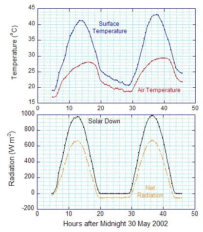
Figure 2. For two clear-sky days at a grassland site in southeastern Kansas, ground surface temperature and air temperature (top), downwelling (downward) solar radiation and net radiation (bottom). Notice how the net radiation goes to zero at about 19 hours past midnight and stays negative until about 5 hours past midnight. All times are local time.
In Figure 2, like Figure 1, the air temperature peaks late in the afternoon; at 16 hours past midnight (1600 or 4 p.m. local standard time) on May 30, and 16 hours past midnight on May 31 (40 minus 24 hours = 16 hours, 1600 or 4 p.m.).
We know the air at 1.5 meters is heated by radiation and convection.
The bottom of Figure 2 shows what is happening with the radiation. There is still energy coming in from the Sun at 4 p.m. (1600) and afterwards (until about 19.5 hours past midnight). However, the downwelling solar radiation isn’t the whole story.
Some of the solar energy is reflected back upward.
Also the air (greenhouse gases), clouds, and Earth’s surface radiate energy in the infrared. On the days represented in Figures 1 and 2, clouds of course are not a factor. Typically, the infrared radiation from the ground is greater than that from the air. The surface infrared radiation is what is measured by the instrument used in the GLOBE Surface Temperature Protocol: the instrument converts the infrared radiation from a surface (the grass, or asphalt, or bare ground) into a temperature. (For further information about the Surface Temperature see “Teacher’s Guide/Protocols” under “Teachers” in the drop-down menu.)
If you add up all the infrared radiation, the net infrared radiation is upward (upwelling).
The net radiation in Figure 2 is the incoming radiation (downwelling solar and infrared) minus the outgoing radiation (reflected solar and upwelling infrared). That is, the net radiation is downward between five hours past midnight (0500) and 19 hours past midnight (1900 or 7 p.m.).
I think I’ve convinced you (and myself) why the warmest air temperature isn’t when the sunlight is strongest. But why isn’t the warmest temperature at around 19 hours past midnight when the net radiation stops heating the ground and starts to go negative?
The reason is that heat is lost through convection.
Air currents carry heat away from the surface. Apparently, at 4 p.m. (1600) local time on both days in Figure 2, the incoming energy from the net radiation just balances the net outgoing energy from convection (convection brings up heat from the ground to 1.5 meters, but it also carries heat from 1.5 meters upward), and the air temperature reaches its maximum. Before 1600 (4 p.m.), the net radiation brings in more energy than convection currents remove, and the air temperature increases. After 1600 (4 p.m.), convection carries away more heat than the radiation is bringing in, and the temperature decreases.
Sometimes we call the adding up of incoming and outgoing heat a “heat budget,” because of the similarity to money. When you save more money than you spend, the amount of money in your bank account — or in your piggy bank — increases. If you spend more money than you save, the amount of money in your bank account or piggy bank gets smaller. When you spending as much as you are putting in, the amount of money stays the same.
What about the surface temperature? This is a little more complicated, because the ground is not only losing energy through convection currents, but it is also losing energy through evaporation and heating up the cooler soil below. These extra losses lead to the surface temperature dropping earlier in the day than the air temperature, around 14 hours past midnight.
At night, things are in some ways simpler. There is no sunlight. On clear nights with little wind, such as those illustrated in Figures 1 and 2, the air and ground keep cooling off by giving off infrared radiation (note that the net radiation at the bottom of Figure 2 is negative throughout the night). Since this continues all night, the coolest temperatures are in the early morning, near the time of sunrise.
Heat transport by air (convection) occurs when winds stir up the air near the surface. This complicates the situation. On average, convection tends to slow the temperature drop at 1.5 meters, with the minimum near sunrise.
Great Blog! And, I had a couple questions…
You mentioned that the air continues to warm during the day as long as the amount of energy going into heating the air exceeds the amount of energy (heat) lost due to convection. Does that imply that all else being equal, windy days will always be cooler than calm days the same way calm nights will be warmer than breezy ones?
One of the reasons I ask, looking at Fig. 2, I noticed the Net Radiation was nearly identical for the 2 days, but both the air and surface temperature were slightly larger on the second day. I don’t know what the winds were like on those two days, but you say that that they are clear sky days and I would guess there was fair weather – at least I don’t think there were any fronts moving through. If the winds are the same, wouldn’t the convection be the same? And, if so, what other factors are influencing the the air and surface tempratures?