
The two pictures show two forest fires burning to the southeast of where we were hiking on 16 July. We were north of the Charles M. Russell Wildlife Refuge, in northeastern Montana. The wind was strong — 32-48 kilometers per hour — and blowing from the west-northwest.
It is likely that lightning from thunderstorms on the evening of 14 July started both fires — and four more we saw on the 16th. 15 July was cool with light winds, and the ground was wet from the rain, so the fires grew slowly. But on 16 July, strong winds, hot temperatures, and low relative humidity made the fires grow much faster. We had been warned — there was a “Red Flag Warning” for high fire danger — because of an extended drought, hot temperatures, strong winds, and dry vegetation.
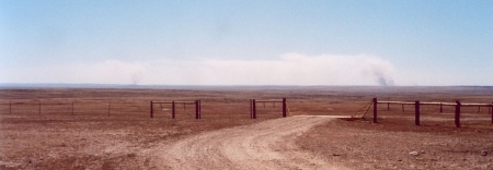
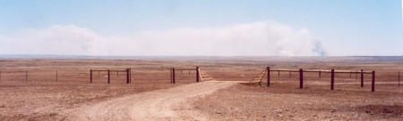 Figure 1. Top: Forest fires to the southeast about noon on 16 July 2006, off Dry Fork Road, north of the Charles M. Russell Wildlife Refuge. Bottom: At same location about one hour later. Notice that the smoke reaches farther up off the ground.
As we watched, the plumes of smoke sometimes rose almost vertically, suggesting rapid upward movement. Were we looking at the fires from the side — so that the wind was traveling exactly from right to left — we could have estimated the upward wind speed from the tilt of the smoke plumes. For example, a 1:1 tilt (45 degrees) would mean the hot smoke was rising at the same speed as the wind was carrying it to the left — 32-48 kilometers per hour.
From looking at the position of the fire from different locations as we drove toward Malta, Montana, we guessed that the fire to the right was about 25 kilometers to the southeast of where the photographs were taken.
The next day, we wanted to come back to roughly the same spot, but the wind had changed to southeast, carrying the smoke directly toward us. We could barely see distant hills, and it was hard to breathe. The wind direction change was good for the firefighters, however, since the fire was being blown back over fuel (e.g., trees or grass plus fallen leaves, etc.) that had already burned.
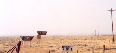 Figure 2. Signs of Dry Fork Road off U.S. 191, showing poor visibility on the 17th of July 2006.
See the January 2004 Chief Scientist’s message and the Fire Fuel Protocol if you want to find out more about wildfires.
Hi Peggy,
Have you ever used FX-Net? They are now the workstation used for fire weather prediction. (http://fx-net.noaa.gov/fx-fire.html – that’s the old page, working on a new one now)
Fire weather is fascinating. Thank you for a great post explaining what weather factors influence the growth of fires!
Ali
G’day Peggy, I reckon that you might be interested to know that we call them bush fires down here in Australia. It was interesting for us to watch some of the vegetation changes that happen following a April 2005 bushfire event in a nearby national park.
Makes sense. In fact, some of the fires we saw would more properly be called bushfires. I love your flower pictures! We get more berries here after fires or logging — we got gallons of raspberries 10-15 years ago in the Roosevelt National Forest. Lots of raspberry pies!
However, one of the real problems we have here in Colorado from fires in the mountains is that the lack of vegetation increases runoff and has made some areas much more susceptible to floods.
Cheers, Peggy
Hi Ali,
I have never been involved in fire-weather forecasting, but my first atmospheric field program was to study forest fires. We actually lit simulated forest fires and studies how they interacted with the environment. Needless to say, there were lots of smoke jumpers watching our every move in case our “experiments” got out of control. (This was in preparation for doing controlled burns — we did this in 1969)
Keep me posted on Fx-net! Good to hear form you.
Best regards, Peggy
Thanks Peggy
Your topic is so good on leting us be more careful from the wind blowing way
many regards abdulmajeed zubailah
An interesting read, indeed. Fire weather is a new term to me, but I would say it\’s becoming more relevant as many areas are getting drier and drier. Just take the recent Californian fires for example of how we can expect to see more \”fire weather\”.
As you know — that is what people are expecting. We have had many fires close to where I live — one night we couldn’t sleep all night because the smoke was so bad and it was too hot to close the windows. Another time, I was driving back from a field program with a colleague and he started to think his allergies were acting up — his throat was sore, he felt stuffy — and I noticed the same thing. We finally realized that we were flying through the plume of the Hayman fire, which took place in Colorado in 2002. We were over a hundred miles east of the fire when this was going on. Once we left the smoke (obviously so thin we didn’t know what it was at first), our symptoms disappeared.
I am now not positive where you are getting your information, but good topic. I needs to spend some time finding out more or working out more. Thanks for excellent information I was searching for this info for my mission.
This article is very interesting and exciting
Great article, I love the Phillipines. Keep up the blogging, thanks again.