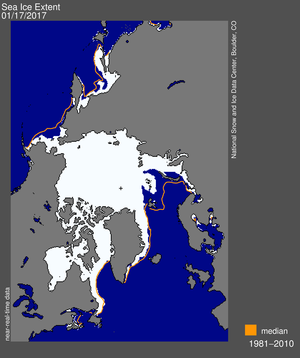
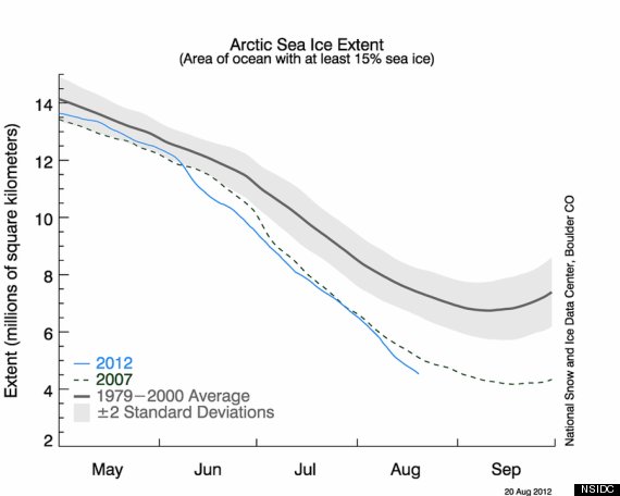
As the northern hemisphere prepares to enter autumn on 22 September, scientists have been looking to the Arctic to gain clues as to what type of winter may be in store. The winters of 2009-2010 and 2010-2011 produced the second and third largest snow cover levels on record. Two years prior, in 2007, Arctic sea ice set a new record low in areal extent.
The Georgia Institute of Technology looked into the connection between Arctic sea ice extent and Northern Hemisphere snow cover. What they found may be critical to seasonal snow forecasts and temperature anomalies across North America and Europe: the lower the sea ice extent, the snowier the winters can be.
Why does this happen? Scientists believe that the enhanced melting of sea ice causes changes in the atmospheric circulation, increases the amplitude of the jet stream and increases the amount of moisture in the atmosphere. Let’s take a closer look at these three impacts.
- Changes in the atmospheric circulation. Because of melting sea ice, the westerly winds are able to decrease. This sets up a “blocking pattern”, which is the positioning of high and low pressure systems, so that cold air masses can move easily from high latitudes to middle and lower latitudes in Europe and North America.
- Increasing the jet stream amplitude. The jet stream is a rapidly moving zone of winds high in the atmosphere. This stream is formed by the contrasting warm temperatures to the south and cold temperatures to the north. The amplitude of the jet stream refers to how far north and south it reaches. So a high amplitude jet stream means there is more than 1610 km between the bottom of the trough to the peak of the next ridge.
- Increased atmospheric moisture. It is easier, energy wise, for water to change state from a liquid to vapor than from a solid to a vapor. Therefore, with more water existing as liquid than ice, evaporation occurs easier than vaporization would. This increases the moisture in the atmosphere in the form of water vapor.
So if there is colder weather and more moisture available, then the conditions become more favorable for more frequent snow events. This report is also timely, because the National Snow and Ice Data Center (NSIDC) is reporting that Arctic sea ice is forecasted to set another record low soon – as early as next week. The difference about this year’s minimum, compared to the low in 2007, is that it is expected to happen very early in the season. Typically the lowest Arctic ice extent is measured in late September, right before the equinox when the Arctic begins to enter a sunless winter. This year’s trend is on track to break the record low and then still have even more time for potential ice melt through the end of the northern hemisphere summer. Only time will tell how low the sea ice extent will go.
This report is timely for many reasons. One, as stated above, is that the northern hemisphere is beginning its transition to the autumn and winter seasons. Second, September brings another occurrence of the Great Global Investigation of Climate, where schools are encouraged to collect temperature and precipitation data. As a GLOBE school, you can be a part of this research – collect your school’s data, obtain records from the NSIDC and compare the two to see if there is a relationship between Arctic sea ice extent and the winter weather in your community.
-Jessica Mackaro


This is both upsetting news and excellent news at the same time. It’s really unfortunate that the North Pole is losing its ice, but if the loss of ice leads to more snow, that’ll wake some people up! Most people hate dealing with snow so it gives one more reason to reduce consumption, reducing climate change.
A great article about global warming. Why do we not undertand what is happing with our planet? What needs to happen till we react and do something against it? Our politicans just talk about changing it, but nothing is happening… it is a sad story but I really hope we wake up soon and it wont be too late