
At a recent meeting, someone commented to me that the “global-warming folks” must be wrong, since we haven’t had a strong hurricane season since 2005, and weren’t they saying that a warmer climate means more hurricanes?
Since we had work to do, I let the comment go, but decided later it would be a good subject for a blog. Particularly since the “official” hurricane season starts on 1 June in the United States.
In 2005, a couple of papers (see references with asterisks, below) came out that implied that there could be more strong tropical cyclones in a warmer climate. (“Tropical cyclone” is the more general term for such storms; “hurricanes” are tropical cyclones that affect North and Central America and the Eastern Pacific north of the Equator.) These papers were well-timed, because 2005 was a devastating North Atlantic hurricane season, with four – Emily, Katrina, Rita, and Wilma, reaching Category 5 on the Saffir-Simpson scale (sustained winds of 155 miles per hour (135 knots or 249 kilometers per hour – henceforth km/hr). Katrina was the most devastating hurricane in memory, with a death toll (well over 1000) exceeded only by the “1900 storm” that destroyed Galveston, Texas and killed between 6000 and 12,000 people. Hurricane Wilma had the lowest central pressure (882 millibars) of any recorded Atlantic hurricane, with sustained winds of 175 miles per hour or 292 km/hr. (The strongest tropical cyclone was Typhoon Tip, whose central pressure dipped to 870 millibars with sustained winds of 190 mph (305 km/hour) on 12 October 1979).
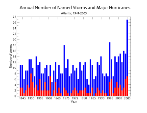
Figure 1. Number of named tropical storms (blue) and named hurricanes (red) by year. From the U.S. National Climatic Data Center.
Finally, 2005 was the year they ran out of names and had to start using Greek letters to name hurricanes, with Zeta, the 26th and last storm, occurring between 30 December 2005 and 6 January 2006. (For the North Atlantic list, names starting with Q, U, X, Y, and Z are left out; the remaining hurricanes were named for the first five letters of the Greek alphabet).
The arguments used for strong hurricanes in a warming climate related to the warming of the sea-surface temperature. Basically, a hurricane is like a heat engine, getting its energy primarily from water vapor evaporating from the warm sea surface, and cooling off at cloud top, around 15 kilometers above the surface.
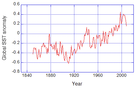
Figure 2. Globally-averaged sea-surface temperature anomaly (sea surface temperature minus mean for 1961-1990). Data from Climate Research Unit, Hadley Centre, UK. (http://www.cru.uea.ac.uk/cru/data/temperature/)
Although there is variation from region to region, the global average of carefully-compiled sea surface temperatures (Figure 2) does indicate a warming. The warming is due to more greenhouse gases in the atmosphere. These gases trap heat in Earth’s lower atmosphere, land surface, and ocean.
However, there are changes superimposed on this long-term trend. In the North Atlantic, these changes can take several decades. The relatively few strong hurricanes during the 1970s and 1980s follow more strong hurricanes in the 1950s and 1960s so this “natural variability” is important as well. One familiar example of natural variability is El Nino, which spreads warm surface waters eastward across the Equatorial Pacific Ocean and affects wind and weather patterns over much of the earth. As noted in previous blogs, aerosols and solar variability can also affect temperature changes on earth, but the effect of the sun is probably fairly minor over the last several decades.
Other things being equal, warmer sea surface temperatures would mean stronger hurricanes. However, other things are not equal. Certain wind patterns favor hurricane development, while other wind patterns do not. For example:
-
Converging winds (more air flowing horizontally into an area than leaving) favor hurricanes. Hurricanes are storms with air near the surface spiraling in to the center, until it reaches the eye wall, where it spirals upward and slightly outward. Such motions are favored in regions where the air is slowly moving upward. This happens where winds converge into an area.
-
Little wind change (called wind shear) with height favors hurricanes. If the wind changes enough with height, it can disrupt the air circulation in a developing tropical storm, keeping it from developing into a hurricane.
-
Wind patterns are much harder to predict in climate models. For example, researchers have found that fewer hurricanes occur during El Nino years. This is because El Nino warms the eastern equatorial Pacific, and this leads to wind shear over the Atlantic basin. But it is not clear how the warming climate will affect the occurrence of El Ninos. If there are more in the future – this effect could offset that of the generally warming sea surface temperatures. Indeed, a new paper by Knutson and colleagues has just pointed out such a possibility. However, it is interesting to note their caution and list of caveats (mostly that the input to their modeling studies is based on global climate models that are still not adequate at regional scales).
What about 2008? On 22 May, the U.S. Climate Prediction Center issued a “2008 Hurricane Outlook” that called for a “90% probability of a near-normal or above-normal hurricane season” in the United States, with the above-normal season more likely (65% chance). Among the factors considered was La Nina (the “cold” phase of El Nino).
As for the rest of the world, the northern hemisphere has already experienced one of the most deadly tropical cyclones in recent history, Cyclone Nargis, which devastated parts of Myanmar and killed tens of thousands of people.
For the longer-term future, the warmer oceans should lead to stronger tropical cyclones – when the wind conditions favor their formation and growth. The real question is how often the favorable wind conditions will happen.
References
*Emanuel, K. 2005: Increasing destructiveness of tropical cyclones over the last 30 years. Nature, 436, 686-688.
Knutson, T.R., et al., 2008: Simulated reduction in Atlantic hurricane frequency under twenty-first century warming conditions. Nature Geoscience, doi:10.1038/ngeo202.
*Webster, P.J., G.J. Holland, J.A. Curry, and H.-R. Chang, 2005: Changes in Tropical Cyclone Number, Duration, and Intensity in a warming environment. Science, 309, 1844-1846.
Hurricane Statistics from
NCDC: Climate of 2005: Atlantic Hurricane Season Summary.
http://www.ncdc.noaa.gov/oa/climate/research/2005/hurricanes05.htlm
Acknowledgments: I wish to acknowledge Caspar Ammann of NCAR for checking this blog and pointing out the Knutson reference.