
Can you guess how hailstone size can be used to measure the strength of a storm? Here, “strength” refers to how fast the air moves upward in the storm: in other words, how strong the updraft is.
Hailstones grow until they are too heavy for the storm to hold them up. For hail to stay aloft, the air the hailstone falls through has to go upward at least as fast as the hailstone is falling downward relative to the air. As the hailstone gets bigger, its fall speed increases — so it will fall until it hits the ground — or finds air moving up fast enough to stop its fall or even carry it up again.
Careful Doppler radar studies of hailstorms and the appearance of hailstones show that the hail makes an interesting journey though the cloud before it falls. The hailstone in the picture has been sawed in half so that you can see what it looks like inside. Do you see the white and clear layers?
Hailstones start out small — as a single frozen raindrop or ice crystal; and, in one case, a fly! (Yes, I mean an actual insect!). Hail grows by getting coated with layers of ice (which “sticks” to the hail) or water (which freezes onto the hail) as it travels through the cloud. For example, raindrops freezing onto the hail form a clear layer, while ice crystals sticking to the hailstone form a white layer. So the hailstone provides a record of the type of precipitation it went through before falling to the ground.
Similarly, your shoes carry a record of where you were when you walk in the mud. As you clean off your shoes, the layers of mud will remind you of where you were. The light layer of mud came from near the school, and the darker layer of mud from near where you live. The mud on your shoes creates a record of where you walked just as the layers in a hailstone create a record of the conditions the hail has traveled through.
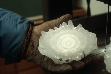
Giant hailstone that fell in Coffeyville, Kansas, showing alternating layers of clear and white ice. The fall speed of this hailstone was estimated to be 47 meters per second. Scientists don’t know what causes the “bumps” on the hailstone, but one hypothesis is that they grow like icicles from water flowing around the hailstone as it falls (remember — the hail is falling faster than the rain!). Picture courtesy of the National Center for Atmospheric Research.
Many books on weather show diagrams of hailstones making several up-and-down trips — perhaps riding the updraft up to where the ice is, then falling to where the rain is, and then getting caught up in an updraft (perhaps the same one), and then falling again. However, in parts of the cloud that are colder than freezing (remember, cumulonimbus clouds are very tall, so their higher parts have temperatures below freezing), there is liquid rain as well as ice and snow. Here, the hail can travel through alternating patches of ice and water without going up and down. Even at temperatures above freezing, the hailstone might travel through regions of melting ice particles as well as rain. Also, the outer layer of the hailstone could start to melt as it falls, and then refreeze as the hail is carried up to where it’s colder. It’s likely that hail travels in many odd ways before finally hitting the ground. Although scientists have some rough ideas of how hail forms and grows, there are many details to be filled in on exactly how.
You are doing such a good job here. Your explanations of things is perfect. Do you have any idea how old is the hailstone we can see in the picture above? I don\’t expect the exact age but just on average. I don\’t have the foggiest idea of its age . To be honest I have never seen a hailstone much bigger than the seed of a pea but I noticed that some of them are more whitish than others. Is any part of our globe more likely to be hit by big hailstones?
Thank you very much for your encouragement about cloud recognition. Actually, I did this clouds quiz… not only once and I still have difficulties with recognition of all the stratus type clouds. I printed this brand new book about clouds (for the youngest students in GLOBE) but the pictures of stratus type clouds aren\’t clear enough for me.
I am wondering what kind of clouds are more likely to be noticed in this time of year (late autumn)?
Hi Jaga,
If you are asking when the hailstone in the picture fell — it fell in 1970. For years, it was in the Guinness Book of World Records as the largest documented hailstone. (Recently, others have claimed a larger hailstone fell in Nebraska. This hailstone was brought here to NCAR, and I don\’t think it is as big as the Coffeyville hailstone (I have a model in my office), but it was apparently longer, if heavier.
If you are asking how long it took to form the hailstone, the answer is probaby a few hours. Large hailstones tend to form in \”supercell\” thunderstorms, which last for several hours (around 6 hours)…
It is true that there are some parts of the world where hail occurs more often. The U.S. High Plains are one such area. Hail is associated with severe thunderstorms (most common in the Central United States — this is due to a combination of wind change with height and warm, moist air coming north from the Gulf of Mexico). Hail is also associated with thunderstorms over higher elevations. The state of Colorado (where I live) for example gets lots of hail. I have seen hail 2-3 cm in diameter here in Boulder more than once. We also had an experiment in northeast Colorado about 30 years ago to test methods of stopping hail that were developed in the Soviet Union. We didn\’t succeed, but we did learn a lot about hail!
Regarding severe thunderstorms — they can happen anywhere. I actually landed in Toulouse, France, in the middle of a severe thunderstorm that had winds of 33 m/s. It was scary.
It\’s hard to take a good picture of a stratus cloud, as well as altostratus clouds. I recently took a picture of an altostratus cloud in Canada and will post in the blog soon. (People don\’t like to photograph altostratus clouds — they are just not very pretty! )
)
As for the Elementary Globe book on clouds — we tried very hard to find good pictures — but it is difficult to find good pictures of stratus and altostratus clouds.
It is true that there are some parts of the world where hail occurs more often. The U.S. High Plains are one such area. Hail is associated with severe thunderstorms (most common in the Central United States — this is due to a combination of wind change with height and warm, moist air coming north from the Gulf of Mexico). Hail is also associated with thunderstorms over higher elevations. The state of Colorado (where I live) for example gets lots of hail. I have seen hail 2-3 cm in diameter here in Boulder more than once. We also had an experiment in northeast Colorado about 30 years ago to test methods of stopping hail that were developed in the Soviet Union. We didn\’t succeed, but we did learn a lot about hail!
Great series.I’ll be back to get useful information.Tks u!
In picture it looks like a carved ice cubes,really great.In my country sometimes hail damage but nothing serious.That’s about the time when I was little interesting.