
If you’ve used a GPS unit, you know that the elevation readings vary faster than latitude or longitude readings. Sometimes the elevation readings change rapidly. Thus, when I took my GPS readings, I wrote down the elevation, than I wrote down the latitude and longitude, and then checked the readings again. If anything changed, I used the average. Usually latitude and longitude did not change, but elevation always did. When I was walking around the oval circuit, I would watch how the elevation changed, and it seemed to go from high to low values and back again about once every three minutes or so.
Figure 5 shows the GPS elevation for the five periods, for the Western Point on the circuit, and for the Eastern Point on the circuit. Let’s look at the Eastern Point graph first. This graph is called a bar graph or histogram. The measurements for the different days are in different colors. The numbers along the bottom are the elevations in meters. Not all the elevation numbers are on the graph, but you can guess what the missing numbers should be. For example, halfway between 1643 and 1647 is 1645. The bars represent observations between the numbers at their edges — a range of two meters.
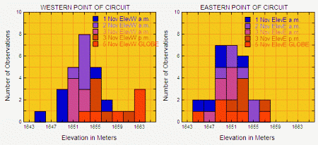
- One just above where “1645″ meters should be on the graph (meaning there is one measurement between 1644 and 1646 meters).
- One at 1647 meters (one measurement between 1646 and 1648 meters).
- Two at 1649 meters (that is, two measurements between 1648 and 1650 meters). Here the squares “run together”)
- One at 1653 meters (one measurement between 1652 and 1654 meters).
So the elevations varied from as low as 1644 meters to as high as 1654 meters — up to 10 meters — on 1 November. We would need the actual numbers of course to know the range exactly.
It looks like the average Eastern Point elevation for 1 November is the lowest of the 5 days on the graph, since the blue squares are mostly above the lower numbers. Similarly, the brown squares are mostly above the highest numbers, so it looks like the average measured elevation is highest on 3 November in the afternoon. This is just what we see on the table below.
| Date | Western Point Elev. (meters) |
Eastern Point Elev. (meters) |
| 1 November 2006 a.m. | 1651 | 1649 |
| 2 November 2006 a.m. | 1652.5 | 1652.3 |
| 3 November 2006 a.m. | 1651.3 | 1649.7 |
| 3 November 2006 p.m. | 1656.5 | 1653.3 |
| 5 November 2006 GLOBE | 1659.2 | 1650.7 |
| AVERAGE | 1654.1 | 1651.0 |
Now the Western Point. Again, it looks like the blue squares are mostly near the low numbers, which suggests that the average elevation is the lowest on 1 November. The table shows that the average elevation measurement on this day is the lowest of the five days — but not by much! 3 November a.m. (1649.7 or pink in the figure) is almost as low. The range of values at the Western Point on 1 November is between as low as 1644 meters and as high as 1648 meters — up to 14 meters! When is the highest elevation measured at the Western Point? In the table the highest elevation is measured on 5 November. Does this look right from the Figure?
The actual elevation of the Western Point, from a topographic map, is between 1646 and 1652 meters, so the average value in the table — 1654 meters — is a little too high. If we take 1649 meters as the true elevation, the highest single value, between 1662 and 1664 meters, from the figure, is up to 15 meters too high. The highest daily average in the Table, 1659 meters on 5 November, is 10 meters too high. The five-day average, 1654 meters, is only five meters too high. Thus averaging the observations on a given day give a better answer than the single points. And averaging measurements over more than one day makes the estimated elevation even better, but most people don’t have the time to do this!!