
Based on these measurements, following the GLOBE GPS protocol and similar averaging procedures improves the precision of position and elevation estimates by about a factor of two. Biases (being too high or too low) are harder to identify, but the average elevation during my test appears to be high by about five meters, and the average elevation on a given day was off by up to 10 meters. Being off by elevation by ten meters will lead to about a one millibar bias when station pressure is converted to sea level pressure. Being off by 10 meters horizontally could put you in the wrong Landsat pixel Hence the extra work in the GLOBE protocol seems justified for these purposes.
Exact location becomes less important for many things, so one GPS reading would be enough. A few months ago, GLOBE and the National Optical Astronomy Observatory had a Web-based field campaign called GLOBE@Night to measure light pollution. This was done by looking for stars visible in the constellation Orion. The more stars you could see, the less light pollution there was. In this case, the observers didn’t need as precise GPS readings, because light pollution wouldn’t change much in 10 meters. Similarly, clouds will look similar to two observers 100 meters apart. I always take GPS measurements as carefully as I can, however — because sometimes I need better accuracy than I originally thought. In fact GLOBE@Night asks you to record all the decimal places for latitude and longitude on your GPS unit.
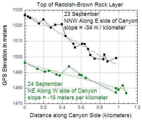
Let’s go back to my earlier question, “Why were we able to use GPS elevation to determine how a rock formation sloped horizontally?” Look again at the elevation plot (below). On a given day, it looks like individual elevations could be off (relative to the line) by five meters, either due to GPS error, or due to our not being exactly at the top of the reddish-black rock layer. However, the elevation of the rock layer changed by over 30 meters in the kilometer over which we took measurements on 23 September. Also, we took about 20 measurements along that kilometer, which is in some sense like using four averages of five points. Similarly, the elevation change was about 20 meters over a kilometer along the line we walked on 24 September, and we took 15 measurements (3 sets of five). Finally, all of our measurements on both days were taken in about two hours. Over a longer period, we would expect the average to change, much as it does from day to day in the elevation graphs and table.
Some hints in taking GPS measurements:
- Nearby terrain can block satellites and make GPS readings less accurate. That could be why there is more scatter for the Western Point elevation graph, which was closer to the mountains than the Eastern point graph.
- Your body also blocks the satellites. It’s best to hold it over your head or away from your body. If you are holding the GPS in front of you, it’s best to face the Equator, since the GPS satellite orbits keep them in the lower latitudes longer. During my tests, I think this might have also led to greater scatter at the Western Point, because I was holding the GPS unit waist-high and was facing north. At the Eastern Point, I faced east. (Of course the GPS was on the ground when we took the rock layer elevation measurements.)
- Averaging seems to improve precision and accuracy. However, the average on a given day can still be too high or too low.
- You should take measurements to five decimal places if they appear on your GPS unit. 37.35000 degrees North is five meters south of 37.35005 degrees North. If you follow a careful procedure to get 37.35005 degrees North, you don’t want to add error by missing the last decimal place!
Just for fun, why not take some GPS measurements at exactly the same location and see how they change from day to day?
GPS been applied in many areas of life. Technology has come so far from our imagination.