
in the last blog, we talked about higher dew points in Chicago heat waves. Last week, I was fortunate to ask Professor Gene Takle of Iowa State University about Iowa dew points being higher than they used to be.
He has noticed the same thing: Iowa summer dew points are getting higher, and not just during heat waves. Figure 1 shows the changes in summer dew points over the last 25 years for three U.S. cities. You can see from the graph that the green line (Kansas City) and the red line (Des Moines) both show dewpoints getting higher with time on average. They also plot the dew points in St Louis, which have risen — but not nearly so much. Figure 2 shows the locations of the three cities.
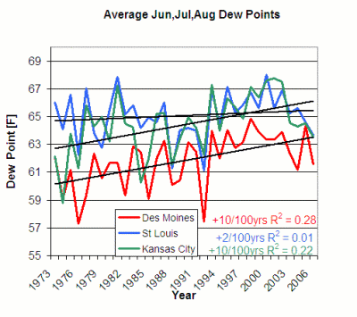
Figure 1. Dew Points (degrees Fahrenheit) for three U.S. Cities, for the last 30 years. Figure from Daryl Herzmann, Iowa Environmental Mesonet. For comparison, the Chicago dew points during the heat waves were getting warmer by 8 degrees per 100 years.
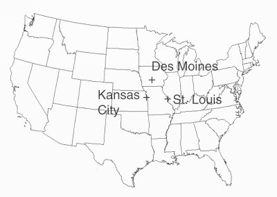
Figure 2. Location of the three cities represented in Figure 1.
As in the paper by Changnon and his colleagues, Professor Takle suspects that more corn and soybeans have helped raise the summer dew points.
Further, Takle notes — the high temperatures in much of the central United States have become cooler over the last 25 years. In fact, according to Houghton et al. in Climate Change 2001: The Scientific Assessment, the June – August maximum temperatures in the Iowa region went down by between 0.2 and 0.8 K per decade between 1976 and 2000, based on the size of the dots which indicate temperature change. (However, the low temperatures probably got warmer).
If temperature and dew point changes are related to more corn and soybeans, the explanation is simple. The energy from sunlight can go into evapotranspiration (water vapor going into the atmosphere from the soil and plants) or heating the ground. More evapotranspiration means both a higher dew point and less energy for heating the soil and the air – and the temperature doesn’t go up as much. (This of course only works if there is enough water in the soil for the crops to use.) So, the areas with rapidly-growing crops don’t warm as much. Note that other crops are grown in the Midwest as well, with wheat being more important toward the west of the Corn Belt.
But — is this all corn and soybeans? Or, as Changnon et al. cautioned — could a change in weather patterns be happening also?
Takle teamed up with Zaitao Pan of St. Louis University and some Iowa State colleagues to run a regional climate model to find out.
The regional climate model uses a global climate model to fill in the weather at the edges. (For example, if you are running a model to show how weather changes across the United States, you need to know about highs and lows, warm and cool temperatures, etc — that are coming in from the sides.)
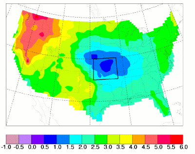
Figure 3. Map of predicted temperature change between the years 1990 and 2040. The numbers represent the change in high temperature. From Pan, Z., R. W. Arritt, E. S. Takle, W. J. Gutowski, Jr., C. J. Anderson, and M. Segal, 2004: Altered hydrologic feedback in a warming climate introduces a “warming hole”. Geophys. Res. Lett. 31, L17109, doi:10.1029/2004GL020528.
Figure 3 shows some results. The map shows a warming at all locations, with larger changes in the west and north part of the United States – but only small changes (blue) for the central part of the country. They call this a “warming hole”.
Their explanation for the “warming hole” is a change in the winds. The authors say that the low-level jet, which brings warm moist air up into the center of the country from the Gulf of Mexico, shifts to the south, so that it targets the cool blue area on average. (A “jet” is a region where strong winds are concentrated; the low-level jet occurs in the lowest 2-3 kilometers of the atmosphere.) This jet flows from south to north; bringing up moisture from the Gulf of Mexico. Faster winds and a warmer Gulf (more evaporation off the water) mean a larger moisture supply to the blue area.
And the blue area — the warming “hole” — is where more rain falls as a result. More rain means wetter soil; and wetter soil means that the corn and soybeans have an ample supply of water to draw on. And this means more solar energy going to evapopotranspiration of water instead of warming the temperature. Also, there are more clouds predicted, which slows down heating. So it gets warmer in the warming hole — but just a little bit. And the dew points stay high.
But — they say that the change in the low level jet is related to drier soils in Texas! The drier soils in Texas help shift the weather patterns, and thus help to create the warming hole.
So — the explanation now involves a shift in weather patterns in creating the “cooling hole” instead of crops alone. This is a perfect example of why scientists keep digging even though they think they know the answer. When you first find out your first idea wasn’t quite right — you might be unhappy for a little while. But in the end — it’s fun to be surprised. You know then that there are some more mysteries to solve. (I’m not sure these scientists ever thought the explanation involved crops alone — but I did at first!)
And there are some problems with this kind of model, since the climate model used to provide the model in Figure 3 with information at the model edges doesn’t know about these small-scale effects, or the small scale effects in the rest of the world. People are still trying to understand this. And I wouldn’t be surprised if Pan and his colleagues are still working on the Iowa dew point mystery.
I would like to thank Professor Takle for providing this information and answering my questions. He also supplied Figures 1 and 3.