
Those of you who have taken GPS measurements to characterize your GLOBE observation site know that the “elevation” on the GPS unit often varies a great deal. That’s one of the reasons the GPS protocol requires that you take five measurements instead of just one.
In tracking the rock layer (see last blog), we didn’t stay in one place very long, and we averaged two hurried measurements at each location. So why were we so successful in tracking the rock layer? To find out more about the accuracy of the GPS elevation, I did an experiment, which I will now describe.
We live on the top of a mesa, inside an oval formed by the street and sidewalks. One trip (circuit) around the oval on the sidewalk is about 500 meters. I picked a point at the west end of the oval (the Western Point), where there was an oil stain just large enough for me to put both feet on). I picked a second point at the east end of the oval (the Eastern Point, where there was a distinctive set of cracks in the surface). Thus I could repeat measurements at exactly the same two points.
To do the rock layer observations, we walked and stopped only long enough to get the two GPS readings. So I decided I would do the same thing in the oval. The next three mornings, I got up early and walked around the oval six times. I stopped at the Eastern Point and the Western Point, just long enough to take two GPS readings of latitude, longitude, and elevation. On the third day, I took the same measurements in the afternoon. Two days after that, I stayed at the Eastern Point and took position measurements using the GLOBE protocol (except with six measurements instead of five, to have the same number as the other days). Then I went to the Western point to obtain six positions and elevations the same way.
How did I do with GPS position?
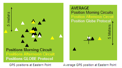
Notice that the positions on the last two days (white and yellow) changed by over 10 meters if you use only one point to define your position.
The second figure shows the average for each day at the Eastern Point. the “+” marks the average position for all the days. Three points — for two of the “morning” circuits (black triangles) and for the GLOBE averages (white triangle, upside down so that you can see the black triangle underneath), were close to the average position. The farthest point from the average is only about 3 meters away. This is about as good as I think I can do with my GPS unit.
Peggy,
What a great way to visualize why it is important to take 5 readings in the same location. I will share this with Iowa teachers. I think it would be a great science fair project for a middle school student to repeat your experiment for additional locations and quantify the levels of accuracy for the different methods.
Take care and Happy Holidays!
Marcy
Hi Mercy,
Great! Yes, it’s a fun and fairly easy project to do. Regarding people blocking GPS signals, someone told me last week that we are “bags of water” to electromagnetic waves. Doesn’t that sound wonderful!
Happy Holidays to you also.
Peggy