2019-10-09 Latitude and longitude data-1 - GLOBE Data User Guide


GLOBE Data User Guide

To discover all the various ways to use GLOBE data, download the GLOBE Data User Guide (PDF) (version 2.0, effective 30 December 2022).
Learn how to access and interpret GLOBE data with this Data User Guide. Inside, members can find appendices on GLOBE's associated metadata, the types of variables available for download, primers on our different protocols and more.
Also refer to our sample python scripts to see how to call and interact with our API (also linked below)
GLOBE data is collected and submitted by GLOBE-trained teachers, students and citizen scientists. GLOBE also collects additional data from automated weather stations and individual data loggers. Through the hard work of these participants, over 200 million measurements have been logged into GLOBE archives and made available for public use.
Version
1.0 of the Data User Guide is available for reference.
Latitude and longitude data
9 October 2019
Effective September 15, 2019, the site location as defined by the Military Grid Reference System (MGRS) and the true latitude and longitude of an observation made with the NASA GLOBE Observer mobile app are both returned by the GLOBE Advanced Data Access Tool (ADAT),GLOBE Visualization System (Vis), andGLOBE Application Programming Interface (API) in the downloaded dataset. GLOBE Observer data are impacted (i.e., observations made with the Observer app). Need help? Contact help@globe.gov.
Background
GLOBE uses the Military Grid Reference System (MGRS) as a reference geographic coordinate system. You can read more about the MGRS grid in the GLOBE Data User Guide. If a user queried the GLOBE database, the user would see a latitude, longitude, and elevation associated with each GLOBE observation in the downloaded dataset. For data submitted via the GLOBE Online Data Entry Form, GLOBE Data Entry app, or GLOBE Email Data Entry, the latitude, longitude, and elevation in the downloaded dataset were the location data input by the participant. For data submitted via the GLOBE Observer mobile app, the latitude, longitude, and elevation in the downloaded dataset were defined at the lower left corner of the associated MGRS gridbox and were based upon the first observation submitted from any participant and any protocol that fell within the associated MGRS gridbox.

What changed?
Effective September 15, 2019, the site location as defined by the MGRS grid and the true latitude and longitude of an observation made with the NASA GLOBE Observer mobile app are both returned by the GLOBE Advanced Data Access Tool (ADAT),GLOBE Visualization System (Vis), andGLOBE Application Programming Interface (API) in the downloaded dataset. Data submitted via the GLOBE Online Data Entry Form, GLOBE Data Entry app, or GLOBE Email Data Entry are not impacted. This change only affects GLOBE Observer data.
Effective September 15, 2019, satellite matching for GLOBE Observer Clouds is now utilizing the true latitude and longitude. Previous GLOBE Observer data was matched coincident to MGRS.
The “true” location of an Observer measurement is the latitude and longitude recorded by the Global Position System (GPS) reading from a person’s mobile device. The GLOBE Observer app does not convey GPS elevation, but instead a Google web service is used that determines elevation based on WGS84 EGM96 geoid height.
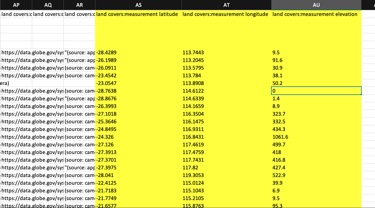
Below is an example of the new, updated data output from ADAT . The example is for land cover data. The site latitude, longitude, and latitude associated as defined by the lower left corner of the MGRS grid box are in columns E, F, and G, respectively.

The true GPS latitude, longitude, and elevation of GLOBE Observer measurements are in columns AS, AT, and AU respectively.
Here is an example of land cover data output from the GLOBE API. The variables "latitude", "longitude", "elevation" highlighted yellow are the site location as defined by the lower left corner of the MGRS grid box.

The variables "landcoversMeasurementLatitude", "landcoversMeasurementLongitude", "landcoversMeasurementElevation" are the true location of an Observer measurement.
