

Current Data Collection Opportunities


Current Data Collection Opportunities

There are many ways to “do GLOBE!” Browse active data collection opportunities to start collaborating with other citizen scientists and scientists around the world.
Global Opportunities
|
NASA scientists working on the PACE satellite mission are asking for your help to collect Clouds observations when the PACE satellite is passing over your location. PACE Atmosphere lead, Dr. Andy Sayer, is interested in comparing your ground-based observations of clouds to PACE data to get a sense of how well PACE measures cloud edges and total cloud cover. Dr. Sayer is specifically looking for GLOBE Clouds observations taken within a 5-minute window of PACE passing overhead during the PACE Clouds Challenge, which will run from 15 September to 1 November 2026. |
|
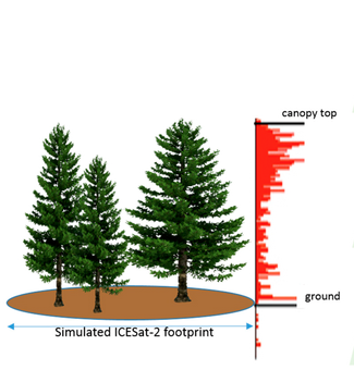 |
Trees Around the GLOBE Campaign Created in conjunction with NASA's ICESat-2 satellite launch, the Trees Around the GLOBE Campaign focuses on providing ground-truth tree height measurements for NASA scientists. By studying the height of the trees in a particular area, researchers can construct 3D models of a forest's canopy, informing them on a number of environmental factors from the land's carbon and to how the ecosystem itself functions. In this campaign, participants can gather data on the tree height in their local habitat as well as baseline measurements like air and surface temperature. Intensive Observation Period: August 2026 Did you know that the United States Department of Agriculture has designated the month of August as "Tree Check Month"? This Intensive Observation Period (IOP) asks GLOBE volunteers to take as many Tree Height and Land Cover observations as possible during the month of August 2026 and to note any pests or signs of damage in the trees or surrounding land cover. Learn more and join the IOP!
|
 |
A global collaboration between scientists, local governments, public health officials, and the GLOBE community, Mission Mosquito focuses on monitoring changes in the frequency, range and distribution of potential disease vector mosquitoes. By combining ground-truth mosquito larvae measurements with NASA satellite data, researchers can determine important information about mosquito habitats that local governments can then use for public health initiatives. In this campaign, participants can use the GLOBE Observer Mosquito Habitat Mapper mobile app to photograph bodies of standing water, determine the number and species of mosquito larvae present, take a Land Cover observation also, and, if possible-dump or tip water in containers. |
Regional Opportunities
|
Leaf Change Tracking for the PACE Mission Use the Land Cover tool in the GLOBE Observer app to take observations of forested landscapes to track leaf color change. “Feature Photos” can be used to capture an image of the area with the most color. Leaf color changes rapidly and regular repeat observations are appreciated! Your observations will help scientists verify PACE vegetation color indices to support the refinement of a novel data product. This data collection opportunity is part of the North American Phenology Campaign which also encourages participants to monitor leaf change on individual trees using the Green-Down protocol, however, observations from all GLOBE countries are welcome. |
Questions
For more information on current GLOBE Data Collection Opportunities, contact the GLOBE Implementation Office.