Science of the CLC - Climate and Land Cover Project


Science of the CLC
To study climate, there are many processes and interactions that occur in the earth system that we must understand. Many of these processes are related to two primary aspects of climate: temperature and water. The temperature is affected by the radiation from the sun and how that radiation interacts with the atmosphere and land surface. Radiation (in the form of heat) is also emitted by the land surface and interacts with gases in the atmosphere that also affect temperature. Carbon dioxide is an important gas in the atmosphere for climate because it absorbs radiation that has been emitted from the land surface, warming the air temperature. The water cycle depends on precipitation from clouds to replenish water on the ground, and on evaporation from the land surface and evapotranspiration from plants to put water back into the atmosphere to make the clouds and precipitation. Notice that both of these aspects of climate are influenced by the land surface!
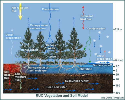
The Earth has many types of surfaces - mountains, hills, forests, lakes and seas, plants, and manmade structures. Each of the surfaces differs in how it interacts with the atmosphere (illustrated in Figure 1). For example, more water will typically evaporate from a lake than from a pasture of the same size, and dark barren soil will absorb much more solar radiation than a bright snow surface. The plants in vegetated surfaces take carbon dioxide out of the atmosphere, while urban locations may be a source of this gas into the atmosphere (i.e. cars, industrial emissions). Therefore, having a detailed understanding of land surface types is critical to study climate. Especially because scientists use computer models to study how changes in the earth system affect climate, so they need to have detailed maps of the land surface types for the model to understand how and where to calculate the different interactions with radiation and the water cycle.
Scientists currently rely on satellite measurements of the land surface to map out the various land surface types and input these maps into climate models. However, they need to be able to validate that the maps are correct with measurements (photographs) taken on the ground. These measurements are called in situ measurements because they are taken directly "in place" where you are collecting the data, as opposed to the satellite observations that are called remote sensing measurements because they are collected from far away.
Scientists need a better representation of relevant land surface features and their temporal (seasonal) variations to use in climate models. Several groups at the National Oceanic and Atmospheric Administration (NOAA) Earth System Research Laboratory (ESRL) are working with satellite-based programs to improve and extend their global and regional observations of surface properties. Computer modelers from the National Center for Atmospheric Research (NCAR) are relying on these improved land cover observations that also show seasonal variations to input into their climate models. NOAA and NCAR scientists invite GLOBE schools to participate in this project to help improve the land cover classification maps that will be used in climate models. It is a big effort to be able to collect detailed in situ measurements of land cover many times throughout the year and from all over the world, but it can be done with the help of GLOBE schools and that will improve climate models for the future!