Cloud FAQ - Clouds Protocol


Clouds Frequently Asked Questions
1). Does the Sun or black holes affect NASA's satellites?
Satellites in space face a problem called "orbital
drag." This happens when the Sun sends out energy and particles
that make Earth's upper atmosphere expand, like a balloon. When this
happens, satellites have to push through more air, which slows them
down and makes their orbits lower. Big storms from the Sun can make
satellites drop as much in one day as they normally would in a year.
Scientists found that smaller, longer storms can sometimes cause more problems for satellites than short, strong ones. This is a big deal because many satellites are in low-Earth orbit, and if one gets off course, it could crash into another.
NASA studies space weather to keep satellites safe. They watch the Sun and predict when storms might happen. This helps satellite operators prepare and prevent crashes. Even the International Space Station needs to adjust its orbit to avoid falling too low.
As more satellites are launched, understanding space weather is important to keep everything running smoothly in space.
On the other hand, black holes do not affect NASA satellites because they are extremely far from Earth. Their gravitational pull does not extend far enough to impact satellites orbiting Earth.
2). What are clouds?
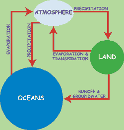
Water on land or in the ocean evaporates, turning from a liquid to a gas called water vapor. The water vapor rises, cools, and then turns back into a liquid, forming tiny droplets. Enough of these droplets make a cloud. When the droplets come together, they combine to form bigger droplets. When they get big enough, they fall to the ground as rain. Or, if it's very cold, they freeze and come down as snow or sleet or hail. Meanwhile, the wind may have blown the cloud a long distance from where its water started. Besides moving water around from one place to another, clouds play a very important part in maintaining.
3). What does NASA do with the data we collect?
While NASA satellites collect a lot of data, they can’t see
everything. Therefore, NASA needs help from people on the ground to
complement the data obtained from satellites. NASA scientists use
the data collected by students like you to do research. For example,
NASA Data Scientist Ashlee Autore most recently looked at GLOBE data
from the past two eclipses, submitted from all over the country. She
used the data to identify any patterns or changes in clouds during
the eclipse. The data you submit to GLOBE helps scientists get a
ground-up view of the Earth, where satellites are a top-down view
and can't capture all the same data that gets submitted through GLOBE.
4). Does NASA need our data?
YES! Satellites do collect important data; however, they
can’t see everything. Sometimes satellites get a bit confused too.
For example, when seeing something white, satellites may think that
snow is a cloud. That’s where you come in. From the ground, you can
help NASA scientists have more information that complements the data
gathered by satellites.
5). How can the satellites see the clouds from outer space? Do you have special technology?
Yes! Satellites take pictures of Earth using special tools.
Different things on Earth reflect or give off different kinds of
light. The special tools measure these different kinds of light,
including visible light that we can see, as well as infrared light
that shows heat, even at night. These tools also convert the light
they detect to electrical signals. Then, there are computers that
change those electrical signals into pictures. Scientists add colors
to these pictures to show details like clouds.
6). How long are the satellites in space?
Typically 5 to 15 years.
7). Why do we have to take pictures of the sky when we make our cloud observations?
Pictures of the sky help scientists have more information.
Satellites gather images of clouds from above. Therefore, those
images let us see the top of clouds. If there are clouds at
different altitudes, those pictures will show only high clouds.
Scientists would like to have photos of low clouds and photos of the
base of clouds.
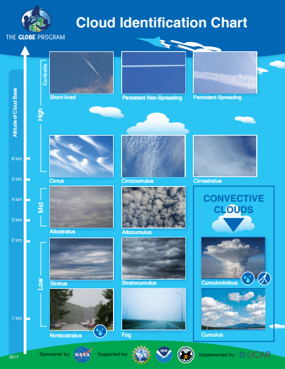
8). If fog is a cloud then why when it says the types of clouds it doesn't say fog is one of them?
Fog does show on the GLOBE Clouds Identification Chart!
Fog forms when the air near the ground cools enough to turn its water vapor into liquid water or ice. Walking through fog is like walking through a cloud at ground level. The next photo shows fog at the top of the Vehicle Assembly Building at NASA’s Kennedy Space Center in Florida.
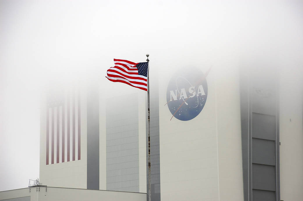
Image Credit: NASA/Ben Smegelsky
9). If clouds are able to appear, how do they disappear? / Why are there only clouds in the air sometimes?
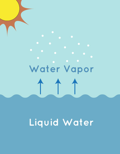
When the water vapor in the air cools, it condenses into droplets or ice crystals. This process happens around tiny particles, like dust, salt from sea spray, bacteria, or ash, called *condensation nuclei*. When enough droplets or crystals gather, they form a cloud. In other words, the water in a cloud is either in liquid or solid form. Clouds dissipate when those liquid or solid water particles turn into water vapor again. That can happen when the temperature increases so the cloud droplets evaporate.
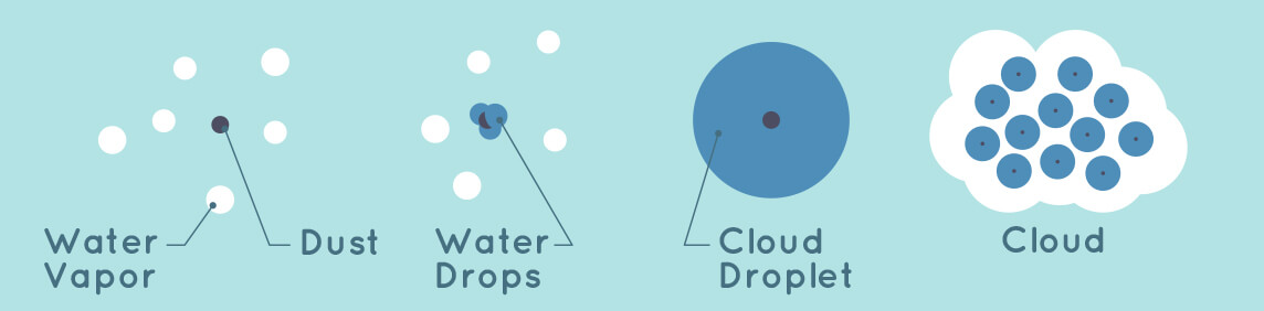
Image credits: Climate Kids/NASA
10). How do clouds form different shapes?
Cumulus (Puffy) Clouds: Air warms up near the Earth's surface
and rises. The ground, heated by sunshine, also heats the air just
above it. Warm air is lighter and less dense than the air around it;
so, it rises. Its pressure and temperature drop causing water vapor
to condense. Eventually, enough moisture will condense out of the
air to form a puffy cloud.
Stratus (Layery/Flat) Clouds: Wind blows into the side of a mountain range or land that slopes upward and is forced to rise. The air cools as it rises, and eventually flat clouds form.
Cirrus (Wispy) Clouds: They first appear in advance of a low-pressure area such as a mid-latitude storm system or a tropical system such as a hurricane. They are made of ice crystals.
11). How fast can clouds move/and how do clouds move?
Clouds can be carried along by winds of up to 150 mph (240
km/h) or can remain stationary while the wind passes through them.
12). How are you able to see/study clouds if they're in the sky; what do you use to study them?
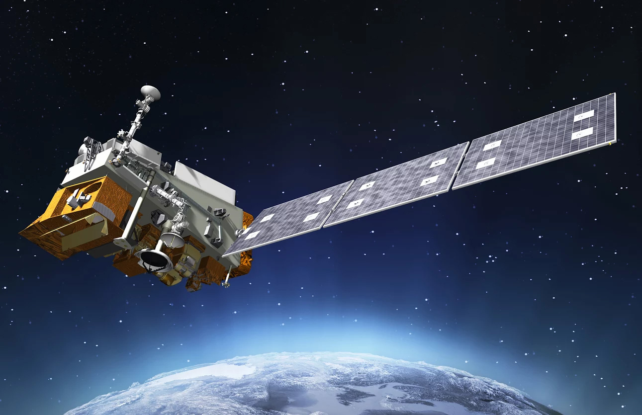
NOAA-20 satellite (Satellite Missions – CERES) | NASA studies clouds from different angles. One of them is by using instruments aboard satellites. For example, CERES (Clouds and the Earth's Radiant Energy System) is an instrument on several NASA satellites orbiting Earth. It measures the amount of energy reflected and given off by clouds at different heights. Some NASA scientists also study clouds by writing computer programs to simulate cloud formation. Learn more about how NASA scientists model the sky. In addition, some NASA scientists use cloud observations from the ground submitted to GLOBE to have a more comprehensive view of clouds because satellites cannot see everything. |
13). What is the lowest height a cloud can go to? What is the highest height that a cloud can go to?
A cloud can form on the ground, in which case it is called “fog”. On the other hand, scientists have called noctilucent clouds, like the one on the image below, “the highest, driest, coldest, and rarest clouds on Earth.” Indeed, most of the planet’s clouds form in the troposphere, the layer of atmosphere closest to the ground, and occasionally in the stratosphere. In contrast, noctilucent clouds form in the mesosphere, at an altitude just over 50 miles (80 kilometers). | 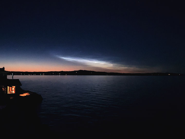
Image credit: NASA Earth Observatory |
14). Do clouds have any weight?
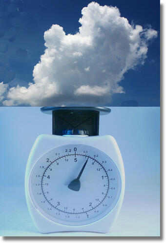 |
Yes! To estimate the weight of a cloud, you can multiply its density X cubic meter. For example, an estimated density of a cloud would be about 0.5 gram per cubic meter. A 1 cubic kilometer (km3) cloud contains 1 billion cubic meters. Doing the math: 1,000,000,000 x 0.5 = 500,000,000 grams of water droplets in the cloud. That is about 500,000 kilograms or 1.1 million pounds (about 551 tons)! Image credit: USGS |
15). How much rain does a cloud hold?
First, let us remember that not all clouds produce
precipitation. Only two types of clouds do: nimbostratus and
cumulonimbus. The nimbostratus clouds tend to produce more steady
rain of low to moderate intensity, they cover a lot of the sky at
low altitudes. On the other hand, cumulonimbus clouds are tall, and
they are associated with thunderstorms and other intense weather.
In terms of cloud water content in general, no two clouds are identical. Therefore, the amount of moisture varies a lot from cloud to cloud. Cirrus clouds are thin and wispy, and they contain much less water than cumulus clouds, which are thick and puffy. Indeed, scientists want to measure how much water is in a cloud to better understand where and how much water moves back and forth between Earth's surface and atmosphere. That information can also help scientists estimate how much sunlight a cloud will reflect back into space and how much warmth that cloud traps near Earth's surface. To give you an idea of how much water a cloud can hold, you can look at the following that shows a global map of "cloud water content". This is a measure of how many grams of water per square meter you would get if you drained all the water out of the clouds into a flat layer on the ground. The white areas show clouds with as much as 1,000 grams of water per square meter; the pink shades correspond to clouds with about 500 grams of water per square meter, and the purple areas represent little or no cloud water content.
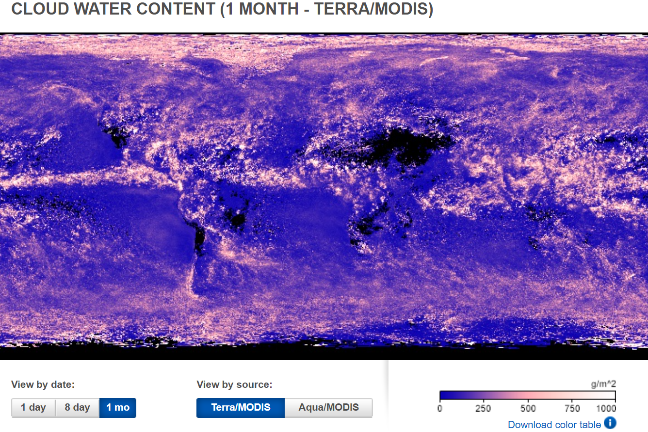
Source: NASA Earth Observations
You can explore cloud water content maps yourself using the NASA Earth Observations website. Click on “Atmosphere” > “Cloud Water Content” and select the date (day, 8-day, or month) that you would like to display.
16). How can someone become a NASA cloud scientist?
First, you need to learn about the atmosphere and you can do
that by going to college and studying a degree in meteorology or in
atmospheric sciences or a similar degree. It is then recommended
that you continue to study and pursue a masters and even a PhD
degree where you can focus on the type of clouds, type of storms, or
technique (air plane or remote sensing) that you would like to learn
to study the clouds.You can learn more on the career connections page on My NASA Data website.
17). Where is the best place to identify clouds and also submit interesting cloud photos?
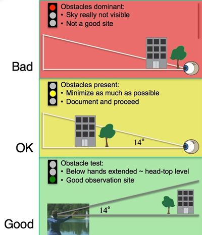
The diagram shows a bad site on the top; the observer can’t really see the sky because a tree and a building are blocking the view. In the middle of the diagram, there is an OK site, where the obstacles only partially block the observer’s view. On the bottom of the diagram there is an ideal site because even though there is a tree and a building, they are below 14° above the horizon; therefore, they don’t obstruct the observer’s view.
Image source: https://cloudatlas.wmo.int/en/clouds-supplementary-features-cavum.html
Noctilucent clouds are rare too. They form in the mesosphere, at an altitude just over 50 miles (80 kilometers). These clouds, also known as night-shining clouds, develop when water vapor aggregates and freezes around specks of meteor dust floating in the mesosphere. | 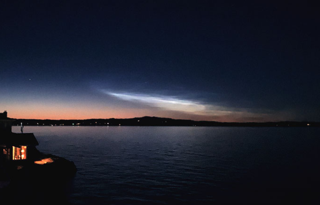 |
Another unusual cloud formation sometimes occurs after a large storm. While most clouds form in rising air and have flat bottoms, clouds known as mammatus have some lumps caused by sinking air that hang on their undersides. These clouds can only form if the sinking air has a lot of water or ice. The sinking air must be cooler than the air around it. | 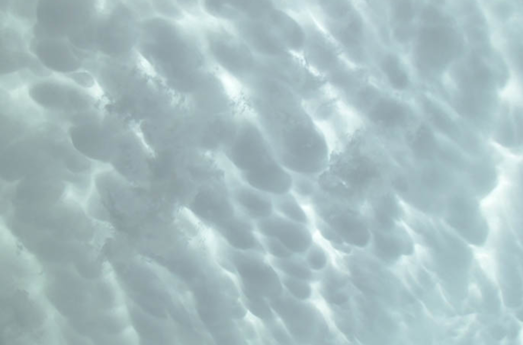 |
No matter where you are, you can catch some interesting clouds. Plus, remember that all your cloud observations are valuable to have a more comprehensive picture of what is up in the sky!
18). Do types of clouds change based on geographical locations?
This is a great question. In general, yes, there are certain
cloud types that are most observed in specific locations. For
example, the beautiful lens shaped lenticular clouds (a type of
altocumulus cloud) are observed near tall mountains, like the ones
observed over Table Mountain, South Africa. You also have
stratus clouds and fog off the west coast of continents in the
midlatitudes. My favorite is supercell thunderstorms (a type of
cumulonimbus clouds) which are formed ahead of a cold front or a dry line, or lead to monsoons and
hurricanes/cyclones. (Response by NASA GLOBE Clouds Project
Scientist, Marilé Colón Robles)