News - Salish Kootenai College


Virtual Student Experience: GLOBE Students Connect, Share, and Learn Together with GLOBE Partners
Ten student research teams were selected to participate in the virtual Student Experience based on their outstanding projects submitted to the International Virtual Science Symposium (IVSS) and the U.S.-based Student Research Symposia (SRS). The invited teams represented six countries—Argentina, Croatia, Mauritius, Oman, Thailand, and the United States—including students from Alaska, California, Michigan, and Texas.
Virtual Student Experience Overview
From 4 June to 11 July 2025, the virtual Student Experience brought together 25 students and three peer mentors for a series of five interactive workshops. Throughout the program, students collaborated to analyze satellite data, develop research questions, and communicate their science stories using ArcGIS StoryMaps. The experience was hosted on the Mighty Networks platform, allowing students to engage and collaborate asynchronously between virtual meetings. A summary of the virtual meetings and learning activities is provided below.
Badges awarded to GLOBE student participants, peer mentors, and
subject matter experts.
One thing from this experience that I'll remember is the one activity, which involved coming up with research questions and editing them to an open-ended question. I feel like that taught me to not only collaborate with my peers but also to better form questions related to data analysis. - GLOBE Student Experience Participant
I will always remember all the wonderful teammates and mentors that I got to work with and learn from! - GLOBE Student Experience Participant
Virtual Meeting 1: GLOBE Data Detectives: What can we learn from GLOBE and NASA Data?
During the first virtual meeting, students began building a sense of community by introducing themselves and participating in a hands-on data activity led by Angie Rizzi, My NASA Data Task Lead at NASA Langley Research Center. In small groups, they analyzed satellite maps showing monthly average surface temperatures from regions around the world. Students then compared these maps with other satellite data, including Incoming Shortwave Radiation and Surface Skin Temperature. The group explored how combining satellite data with ground-based observations from the GLOBE Visualization System can help generate questions and insights about Earth system processes.
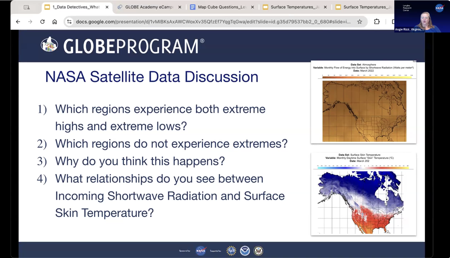
Angie Rizzi, NASA Langley Research Center, facilitates a discussion on interpreting satellite data.
Virtual Meeting 2: Ask it With Data: Framing Earth system questions
In the second virtual meeting, students learned from Brian Campbell, GLOBE Observer Trees Science Lead at NASA’s Wallops Flight Facility. He introduced the GLOBE Observer Trees Tool and explained the importance of measuring trees from both the ground and space. Students explored how tree height data collected by ICESat-2 can be paired with GLOBE Observer Trees observations to study changes in tree growth over time.
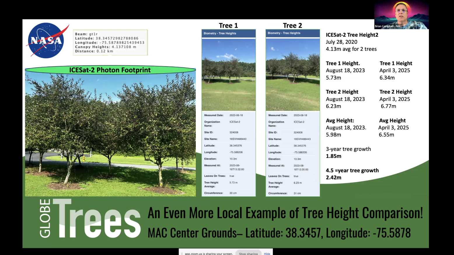
Brian Campbell, NASA Wallops Flight Facility, showcases tree height comparisons from GLOBE and satellite data.
Virtual Meeting 3: Asking Questions About GLOBE and NASA Data
In the third virtual meeting, students participated in an activity designed to help them develop research questions focused on environmental change using GLOBE ground-based data and NASA satellite data. They were joined by Bri Lind, Remote Sensing Ecologist at the Institute for Global Environmental Strategies (GIO-STEPE), who shared key considerations for effectively working with satellite data. Angie Rizzi also demonstrated satellite visualization and analysis tools from the My NASA Data Earth System Data Explorer, and how these tools can be used to help students investigate their research questions.
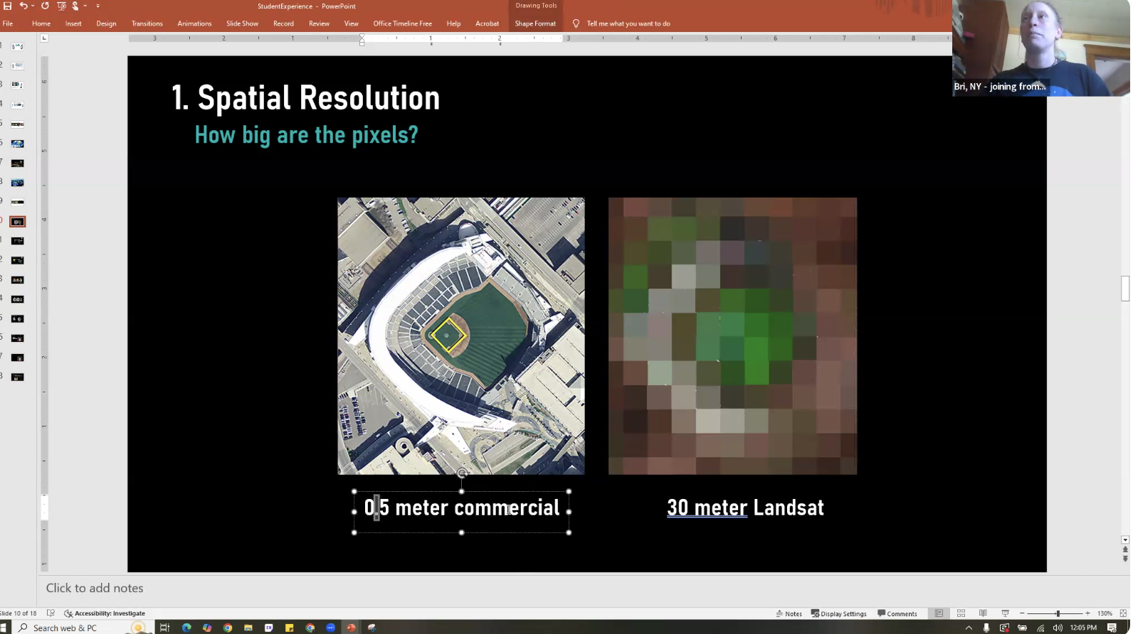
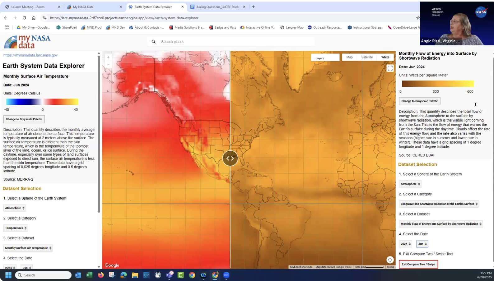
Bri Lind, GIO-STEPE, (top) and Angie Rizzi (bottom) share strategies for exploring and analyzing satellite data.
Virtual Meeting 4: From Patterns to Claims: Telling a data story
In the fourth workshop, students learned data analysis strategies from Tracy Ostrom, GLOBE Program Coordinator and Trainer at the University of California, Berkeley. Working in small groups, they explored example datasets, practiced interpreting data, and discussed which types of data could best support their own research questions.
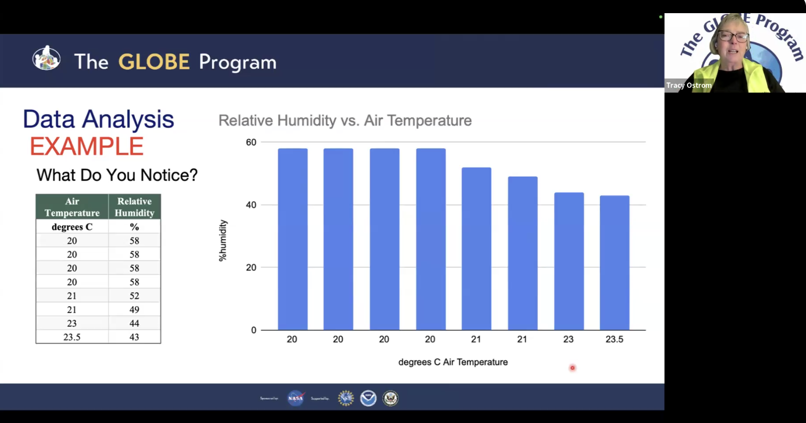
Tracy Ostrom, UC California Berkeley, engages students in a data analysis and interpretation activity.
Virtual Meeting 5: Telling Your Science Story with StoryMaps
In the final virtual meeting, students celebrated with a cultural exchange, sharing stories and traditions from their communities. They also learned how to communicate their science investigations using ArcGIS StoryMaps, guided by Ashlee Autore, My NASA Data Web Developer, and Desiray Wilson, My NASA Data Scientific Programmer. Ashlee and Desiray demonstrated how to integrate GLOBE data into interactive maps, and students practiced building their own StoryMaps to showcase their science stories.
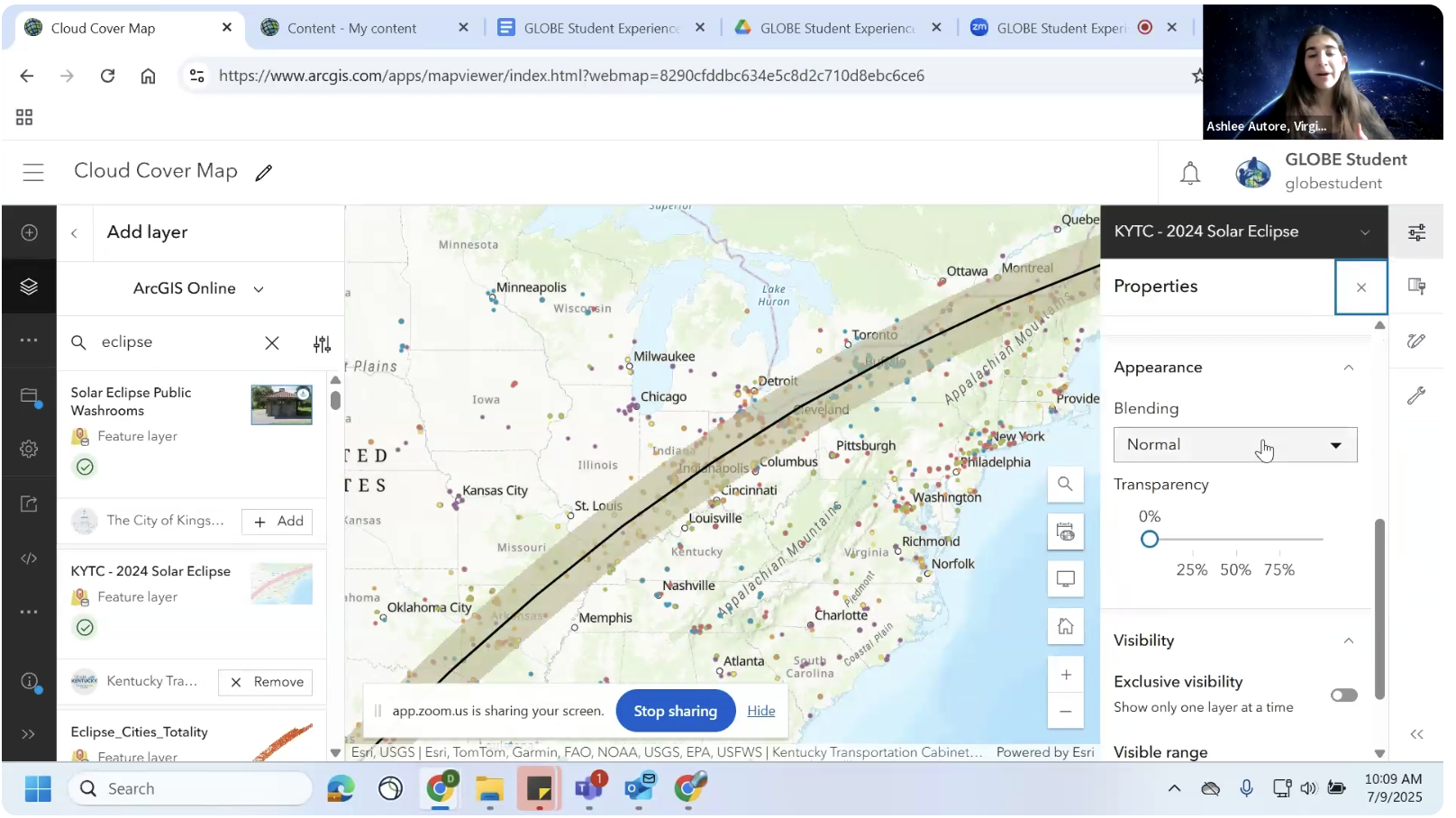
Ashlee Autore, NASA Langley Research Center, demonstrates how to add GLOBE data to an interactive map in ArcGIS.
Student Experience StoryMaps
Working in teams, students developed research questions and created ArcGIS StoryMaps to showcase their investigations and learning. Explore a selection of Student Experience projects through the StoryMaps linked below.
El Niño’s Winter Impacts on the US East Coast
Overpopulation and its Environmental Impacts
Drier Lands: Farming and Climate in the Middle East
Virtual GLOBE Annual Meeting Student Exhibition
Students were also invited to present their IVSS and SRS research projects at the Virtual GLOBE Annual Meeting Student Exhibition on 14 July. Visit the Student Experience Youtube playlist to watch their presentation videos and learn more about these outstanding student research projects.
The virtual Student Experience was led by Alison Mote, GIO Education Specialist, and was a success thanks to the support of several GLOBE Community members. Peter Falcon, NASA Jet Propulsion Laboratory, was instrumental in planning and co-facilitating the virtual Student Research Experience. Thank you to the following GLOBE Partners who served as subject matter experts and led learning activities: Angie Rizzi (NASA Langley Research Center), Brian Campbell (NASA Wallops Flight Facility), Bri Lind (IGES/GIO-STEPE), Tracy Ostrom (UC Berkeley), Ashlee Autore (NASA Langley Research Center), and Desiray Wilson (NASA Langley Research Center). GLOBE Students Andrei Alayon, Malk Alfaghari, and Laura Pardo served as peer mentors, sharing their passion for GLOBE research with the Student Experience participants. Haley Wicklein and Jen Bourgeault, GLOBE U.S. Coordination Office, selected student teams to attend the Student Experience from virtual SRS events and shared resources to support the Student Exhibition at the virtual GLOBE Annual Meeting. A huge thank you to GLOBE Educators for supporting and inspiring your student scientists and to GLOBE students for your curiosity, passion, and stewardship!
Learning activities were adapted from the My NASA Data Earth
System Satellite Images - Analyzing Annual Changes in a
Variable activity and the Right Question Institute’s Question Formulation Technique (QFT).