GLOBE News


Recent Paper Highlights the Potential of The GLOBE Program’s App, GLOBE Observer Trees Tool, to Complement Satellite and Airborne Tree Height Measurements
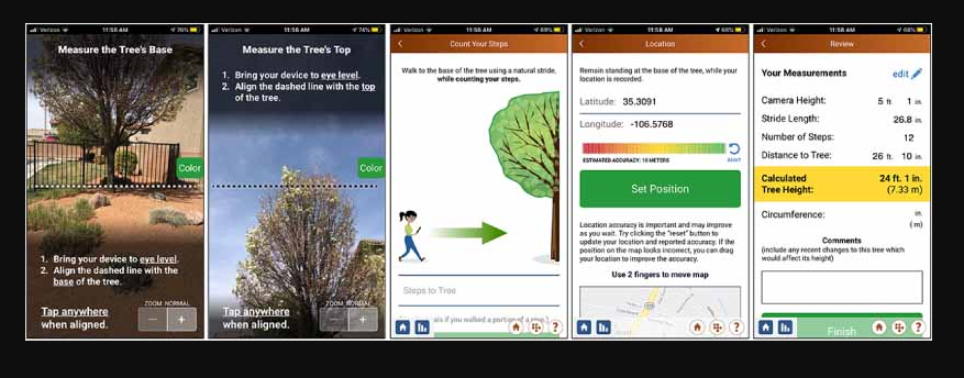
On-screen instructions guide citizen scientists to record the angle to the base and crown of the tree, estimate the distance to the tree, and record its location in GO Trees.
A paper published on 21 June in Environmental Research, “The potential of citizen science data to complement satellite and airborne lidar tree height measurements: Lessons from The GLOBE Program,” focuses on The GLOBE Program’s app, GLOBE Observer Trees tool.
The paper, authored by Josh Enterkine, Brian A Campbell, Holli Kohl, Nancy F Glenn, Kristen Weaver, David Overoye, and Deanna Danke provides an overview of The GLOBE Program and how using the program’s software application, GLOBE Observer (GO) Trees tool, allows volunteers to measure tree height and optional tree circumference, which may support NASA and other space-based satellite data (such as from the Ice, Cloud, and land Elevation Satellite-2 (ICESat-2) and Global Ecosystems Dynamics Investigation instrument.
“This paper describes tree heights data collected through the GO application and identifies sources of error in data collection. We also illustrate how the ground-based citizen science data collected in the GO application can be used in conjunction with ICESat-2 tree height observations from two locations in the United States: Grand Mesa, Colorado, and Greenbelt, Maryland. Initial analyses indicate that data location accuracy and the scientific relevance of data density should be considered in order to align GLOBE tree height data with satellite-based data collections. These recommendations are intended to inform the improved implementation of citizen science environmental data collection in scientific work and to document a use case of the GLOBE Trees data for the science research community,” the authors state in the paper.
The paper also explains how measuring tree height can be used to understand larger environment conditions; how the GO Trees tool provides a mechanism for citizen science-based estimates of tree height by tapping into the phones gyroscope to turn the device into a handheld clinometer; as well as discusses potential errors in GO Trees measurements and GO tree height accuracy testing.
To read the paper, click here.
News origin: GLOBE Implementation Office