Compare Your Cloud Observations with Satellite Data - Clouds Protocol
How to Compare My Cloud Observations with Satellite Data
How can I tell if my observations are correct?
We encourage you to look and compare your observations to satellite data. You may still ask yourself if it was correct. Note how much of your report is about the same as the satellite data on the comparison table. Here are some suggested comparisons:
How does your total cloud cover compare to the satellite report?
The first section on the satellite comparison table contains the
following details about the observation made by one or more satellites
and by you: date & time the observation was made,
latitude/longitude, and total cloud cover. Look across to compare the
satellite data with your observation. See if the cloud cover percent
reported by the satellite(s) is within the range you selected in your observations.
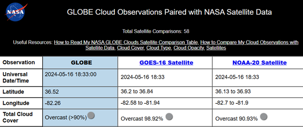
What if the observations don’t agree: Cloud
cover discrepancies can be due to various things. Maybe the satellite
saw clouds at different layers you were not able to detect with your
eyes. Maybe it was hard for you to choose the right range of cloud
cover. We recommend practicing with the fun activity “Make a Simple Cloud Cover
Model”; you can test your skills with cloud covers created by others!
Take it a step further: You can calculate the difference between the satellite cloud cover percentage and your report. If the satellite percentage is higher than yours, then see how far off it is from the highest number in the range you selected. You can do something similar, but with the lowest number in the range you selected, if the satellite percentage is lower than yours.
Did the satellite report clouds at the same levels (low, mid,
high) as me?
Look straight across the comparison table, and see if there are
satellite observations for the same altitude (HIGH, MID, and/or LOW)
that you observed. If you see satellite information (cloud altitude,
cloud phase, cloud opacity, and cloud cover) for the same altitude you
reported, then you AND the satellite agree that there were clouds at
that level!
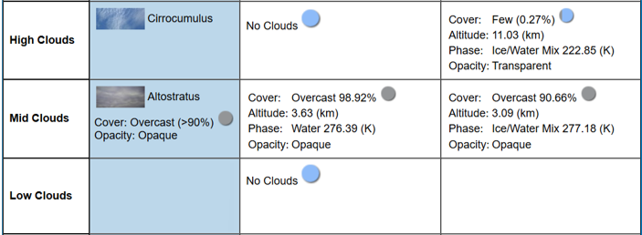
Take it a step further: You can now compare if your observations and the satellite data agree in the opacity and cloud cover for that level.
What if the observations don’t agree: Our view from the bottom up to space gives us the advantage to see the bottom of clouds. It can limit our ability to see clouds at higher levels, especially if the lower level clouds are very thick and cover almost the entire skies. Satellites, which can see the higher clouds, can note if there were clouds higher than those you reported. Does this mean your observations are wrong? Not at all! It is a great time to see if the satellite was able to detect clouds at different heights. Keep in mind that even for satellites, detecting clouds at different heights is not always easy—they can only "see" the top layer of clouds. That is why comparing ground and satellite observations can give a fuller picture of what is happening in the atmosphere.
How can my observations help researchers?
Researchers are interested in your viewpoint of cloud observations compared to satellite data for various reasons. Remember, satellites do not report cloud types, but do report cloud altitude, cloud cover, cloud opacity, and cloud phase.
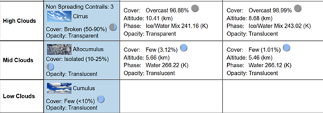
1. Satellites can only see the top of clouds
Some instruments on satellites may not be able to detect cloud layers that are below a cloud layer higher above.
What to look for: On your Satellite Comparison Table, look for instances when you observed and reported low- and/or mid-level clouds, and the satellite data reported is for cloud layers above your report.
2. Clouds that are transparent are hard for satellites to detect
Not all clouds are created equal, and that includes how they interact with energy. Do all clouds cast shadows? No, each cloud type interacts differently with the energy coming from the Sun. Opacity, or how the cloud looks, gives us an idea of how they are interacting with the Sun's light.
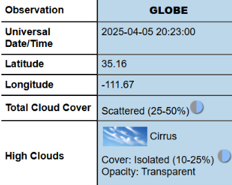
What to look for : On your Satellite Comparison Table, look for instances when you observed transparent cirrus clouds and see if the satellite was able to detect them. These types of cirrus are called sub-visible cirrus. Some instruments are able to detect them, others cannot.
3. Presence of Contrails or clouds produced by airplanes
Contrails are very thin clouds and can be hard to detect by satellites. Your observations are the best method to keep track of the number of contrails around the world.
What to look for: On your Satellite Comparison Table, look for instances when you observed contrails. Note if the satellite reported back high-level clouds. If it did, then you can look for the image found at the bottom of the page and see if you can notice the contrails on the image. Use the “How to read a satellite comparison” to find the satellite images on your satellite comparison table. Use the help pages below on how to read satellite data made for each satellite that you can possibly compare with your observations. If the satellite did not report any high-level clouds, then you know that it was not able to detect them.
4. Clouds present when there is snow or ice on the ground
Not everything that is white a cloud, especially from a satellite’s top-down view. Read the Earth Observatory for Kids newsletter titled Clouds or snow? A Satellite Mystery. See GOES 16 images of the Winter Weather Bomb in January 2018 and see if you can note where the clouds are and where is the snow!
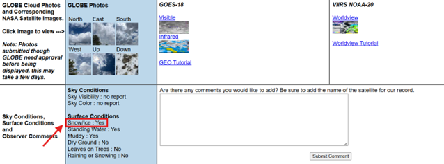
What to look for : On your Satellite Comparison Table, look for instances when you chose “yes” for snow/ice in your surface conditions report, underneath the comparison table and reported clouds.
Use the following link to learn more about interpreting satellite data:
How to Interpret Satellite Data


